Tuesday, 08 February 2022 08:00 AM
Company Update
- Broad Gold Zones - 1.27 g/t gold over 17.3 metres within a zone grading 0.72 g/t gold over 128.5 metres (61.5 to 190.0 metres; True Thickness 45 metres)
- Drilling confirms gold-bearing fault zones with several targets to be drilled in 2022
- Surface sampling includes assays up to 14.7 g/t gold
TORONTO, ON / ACCESSWIRE / February 8, 2022 / Magna Terra Minerals Inc. (the "Company" or "Magna Terra") (TSXV:MTT) is pleased to announce that it has received assay results from its recently completed drilling program at the Rattling Brook Deposit (the "Deposit") on its 100% owned Great Northern Project ("Great Northern"), located in western Newfoundland (see news release dated November 22, 2021). Drilling consisted of 10 drill holes (JA-21-124 to 133) totalling 1,253 metres (the "Drill Program") and was designed to test potential geological controls on gold mineralization by northwesterly trending faults (Exhibit A and B). The Company has also received assays from a mapping and 79-sample prospecting program ("Surface Sampling Program") conducted along the same northwesterly striking fault zone referred to as the Apsy Feeder Zone.
The Drill Program resulted in the discovery of a new zone of gold mineralization, confirming that northwesterly trending faults form favourable hosts to gold deposits. Specifically, gold mineralization was intersected 150 metres northwest of the Rattling Brook Deposit within the Apsy Feeder Zone, both expanding the deposit and confirming the presence of gold mineralization within the fault structures (Exhibit C and D). Further, the Surface Sampling Program resulted in 32% of rock grab samples** being anomalous in gold, including assays up to 14.7 grams per tonne ("g/t") gold and demonstrates along with previous sampling that gold mineralization within the Apsy Feeder Zone continues at surface over 800 metres of strike length (Exhibit A).
Highlight gold intersections (see Table 1 below) from the Drill Program include:
- 1.30 g/t gold over 16.5 metres (151.0 to 167.5 metres; Estimated True Thickness "TT" 7 metres) in drill hole JA-21-131;
- 1.64 g/t gold over 9.7 metres (9.0 to 18.7 metres; TT 9 metres), including 16.60 g/t gold over 0.5 metres in drill hole JA-21-127;
- 0.72 g/t gold over 128.5 metres (61.5 to 190.0 metres; TT 45 metres), including 1.27 g/t gold over 17.3 metres and 1.47 g/t gold over 7.0 metres in drill hole JA-21-129;
- 0.47 g/t gold over 103.0 metres (2.0 to 105.0 metres; TT 95 metres), including 0.98 g/t gold over 33.0 metres in drill hole JA-21-133;
- 0.79 g/t gold over 26.4 metres (121.0 to 147.4 metres; TT 25 metres), including 1.27 g/t gold over 8.4 metres in drill hole JA-21-133;
- 0.49 g/t gold over 65.2 metres (1.8 to 67.0 metres; TT 60 metres) in drill hole JA-21-124; and
- 0.61 g/t gold over 37.4 metres (12.0 to 49.4 metres; TT 35 metres) in drill hole JA-21-132.
"We are extremely pleased with the assay results from this drill program. We have discovered a new gold zone and confirmed a key geological control on mineralization demonstrated by intersecting thick zones of gold mineralization hosted within late faults, such as the Apsy Feeder Zone. The western most drill intercept within the Apsy Feeder Zone also demonstrates that the Rattling Brook Deposit likely extends at least 150 metres west of the current resource. Further, surface rock grab samples** with assays up to 14.7 g/t gold, together with previous sampling, indicate there is significant potential for resource expansion up to 800 metres along strike from the Rattling Brook Deposit with further drilling. Importantly, similar faults to the Apsy Feeder Zone are prevalent throughout the Great Northern Property and are coincident with similar geophysical characteristics, providing numerous additional opportunities for further discovery and resource expansion. Several of these are priority targets for follow-up drilling in 2022 and, in addition to the Apsy Feeder Zone, include targets such as the Incinerator and Furnace Trends as well as others on the district-scale Great Northern Project. The Drill Program and Surface Sampling Program have significantly impacted the prospectivity of the Great Northern Project and set the stage for further discovery and value creation throughout 2022."
~ Lew Lawrick, President and CEO, Magna Terra Minerals Inc.
The Rattling Brook Deposit contains a NI 43-101 Inferred Mineral Resource^ comprising 255,000 ounces at 1.45 g/t gold (5,460,000 tonnes) and is hosted along a 5-kilometre section of the larger Doucers Valley Fault. The Deposit is hosted within three zones, the Apsy, Road, and Beaver Dam Zones, that are open for expansion at depth and along strike. A key controlling feature that has been identified are northwest and east-west striking fault zones that are thought to be potentially higher-grade feeder zones to the Rattling Brook Deposit. Several of these fault zones are not tested and drilling outside of the immediate resource area is sparse.
Drill Program Details
The Drill Program comprised a total of 1,253 metres in 10 diamond drill holes (JA-21-124 to 133) that were designed to test for the northwest expansion of the Apsy Zone Mineral Resource along a 250-metre strike of the Apsy Feeder Zone (Exhibit A and Exhibit B). Drilling was also designed to verify the tenor and geometry of mineralization within the Apsy Zone Mineral Resource by drilling key infill holes on the mineral resource (JA-21-124 and 133).
Drilling in holes JA-21-124 and 133 has successfully reproduced the thickness and tenor of sulphide mineralization and accompanying alteration compared with previous drilling in the area (e.g. JA-05-35 and 36). Drilling has also served to confirm the moderate southwest dip of the Apsy Zone.
Drilling in drill holes JA-21-125 to 129 and 131, served to discover sulphide mineralization and alteration along the Apsy Feeder Zone, effectively expanding the footprint of the Apsy Zone 150 metres towards the northwest. Importantly, drilling in holes JA-21-131 and 129, which were drilled down-dip due to access issues, successfully intersected the Apsy Feeder Zone to a depth of 160 metres (~100 vertical metres).
Drill holes JA-21-130 and 132 tested the up-dip extension to the north of the Apsy Zone Mineral Resource.
Mineralization at the Apsy Zone comprises overall 1 to 3% (locally up to 10%) disseminated and stringer pyrite and arsenopyrite that is closely associated with pervasive sericite alteration. Alteration increases towards the lower contact of the moderately southwest dipping Apsy Zone, where it is marked by near complete replacement of the host granodiorite by sericite and silica often with hydrothermal brecciation of the host rock and a zone of intense shearing and faulting. These zones of more intense alteration are often associated with higher gold grades (> 2.0 g/t gold) in the Apsy Zone.
Table 1: Highlight assay composites from the Apsy Drill Program
| Hole ID | From (m) | To (m) | Interval (m)* | Au g/t |
| JA-21-124 | 1.8 | 67.0 | 65.2 | 0.49 |
and | 73.0 | 74.0 | 1.0 | 1.27 |
and | 83.0 | 85.0 | 2.0 | 0.74 |
and | 89.0 | 93.0 | 4.0 | 0.52 |
| JA-21-127 | 9.0 | 18.7 | 9.7 | 1.64 |
including | 16.2 | 18.7 | 2.5 | 4.42 |
and | 18.2 | 18.7 | 0.5 | 16.60 |
| JA-21-128 | 10.0 | 10.5 | 0.5 | 0.72 |
| JA-21-129 | 39.5 | 43.0 | 3.5 | 0.44 |
and | 61.5 | 190.0 | 128.5 | 0.72 |
including | 151.7 | 169.0 | 17.3 | 1.27 |
and | 183.0 | 190.0 | 7.0 | 1.47 |
| JA-21-131 | 47.0 | 49.6 | 2.6 | 0.27 |
and | 69.2 | 69.9 | 0.7 | 0.53 |
and | 79.3 | 79.8 | 0.5 | 0.55 |
and | 87.3 | 92.1 | 4.8 | 0.42 |
and | 103.3 | 104.3 | 1.0 | 0.53 |
and | 151.0 | 167.5 | 16.5 | 1.30 |
| JA-21-132 | 3.6 | 8.0 | 4.4 | 0.45 |
and | 12.0 | 49.4 | 37.4 | 0.61 |
| JA-21-133 | 2.0 | 105.0 | 103.0 | 0.47 |
including | 72.0 | 105.0 | 33.0 | 0.98 |
including | 92.0 | 105.0 | 13.0 | 1.55 |
and | 110.0 | 113.5 | 3.5 | 0.50 |
and | 121.0 | 147.4 | 26.4 | 0.79 |
including | 127.6 | 136.0 | 8.4 | 1.27 |
Notes:
*Interval presented as core length only, please see TT in highlights above
No significant assays in drill holes JA-21-125, 126 and 130
Previous (1986 to 2007) select drill intercepts that partly define the Apsy Zone adjacent to the area of the Drill Program include:
- 1.77 g/t gold over 74.4 metres (2.3 to 76.7 metres; TT 60 metres), including 3.25 g/t gold over 22.7 metres in drill hole JA-05-35;
- 1.13 g/t gold over 115.7 metres (45.0 to 160.7 metres; TT 70 metres) in drill hole JA-05-36;
- 1.40 g/t gold over 84.6 metres (10.5 to 95.1 metres; TT 80 metres), including 8.62 g/t gold over 2.5 metres in drill hole JA-06-46;
- 1.28 g/t gold over 75.6 metres (1.0 to 76.6 metres; TT 70 metres) in drill hole JA-06-53;
- 1.22 g/t gold over 56.5 metres (61.0 to 117.5 metres; TT 50 metres) in drill hole RB-30; and
- 1.07 g/t gold over 68.0 metres (115.6 to 183.6 metres; TT 60 metres), including 8.84 g/t gold over 1.0 metres in drill hole RB-40.
Surface Sampling Program Details
A program of prospecting was completed to the immediate west and northwest of the Apsy Zone, and along the Apsy Feeder Zone outside of the area tested by the Drill Program. A total of 79 rock grab and float samples** were collected over a strike length of 900 metres along the Apsy Feeder Zone (Exhibit A). Sampling was completed as a follow-up to anomalous rock samples identified during initial prospecting completed during summer 2021 on the Apsy Feeder Zone that identified gold-bearing rock samples assaying up to 3.2 g/t gold (see Press Release dated September 7, 2021). Samples comprised pervasively sericite and sulfide-bearing granodiorite and associated sulfide bearing quartz veins that are coincident with topographic linear features from LiDAR imagery and gold-bearing B-horizon soil samples (assaying up to 1,500 ppb gold).
The rock grab and float samples** assayed up to 14.7 g/t gold with 13 of the 79 rock samples assayed greater than 1.0 g/t gold and 19 rocks samples assaying greater than 0.5 g/t gold. The results of this prospecting program, together with historic soil sampling, support the potential for gold mineralization to continue to the northwest for 800 metres along the Apsy Feeder Zone where it has not been previously tested by drilling.
**Grab and float samples are selected samples and are not necessarily indicative of mineralization that may be hosted on the property.
Exploration Target Details
Several drill targets and specific opportunities for mineral resource expansion and discovery have been identified by the Company based on recent field programs and a comprehensive review of historic and current exploration data (Exhibit C and Exhibit D). This work, in conjunction with that of previous operators on the Property, has identified the importance of fault control on gold mineralization. These major target areas for near-term drill testing are:
- The Apsy Feeder Zone - 800 metre northwest striking fault zone adjacent to and northwest of the Apsy Zone mineral resource;
- Apsy Zone - 1.0-kilometre strike length - potential up-dip extension to the Apsy Zone;
- Incinerator Trend - 1.8-kilometre long gold-bearing east-west fault;
- Furnace Trend - 1.5-kilometre long trend with rock grab samples** assaying up to 5.60 g/t gold along east-west fault zone; and
- Jacksons Arm Trend - 2.4-kilometre long gold zone cross-cut by numerous north and northeast trending fault zones.
Apsy Feeder Zone and Apsy Zone (Rattling Brook Deposit)
The Apsy Feeder Zone is hosted along a northwest oriented fault splay extending from the Apsy Zone that has a moderate south dip and has been identified by the Company and previous operators, to have a significant control on gold mineralization within the host Proterozoic Main River granites and the overlying Cambrian quartzites and phyllites. This fault is potentially associated with higher grades within the Apsy Zone.
The Apsy Feeder Zone and associated fault, gold-bearing rock grab samples (assaying up to 14.7 g/t gold), and anomalous soils extends for 800 metres northwest of the Apsy Zone mineral resource. Recent drilling has extended the Apsy Zone 150 metres to the northwest along the Apsy Feeder Zone.
Recent drill results from the Apsy Feeder Zone include 1.30 g/t gold over 16.5 metres (TT 7 metres) in drill hole JA-21-131; 1.64 g/t gold over 9.7 metres including (TT 9 metres), including 16.60 g/t gold over 0.5 metres in drill hole JA-21-127; and 0.72 g/t gold over 128.5 metres (TT 45 metres), including 1.27 g/t gold over 17.3 metres and 1.47 g/t gold over 7.0 metres in drill hole JA-21-129. These results correspond well with historic drilling at the Apsy Zone that includes 1.13 g/t gold over a core length of 115.7 metres (TT 70 metres) in drill hole JA-05-36 (Exhibit C and Exhibit D).
Recently re-processed historic IP geophysical data outlines a high chargeability anomaly that corresponds with the known Apsy Zone Resource as well as the Apsy Feeder Zone. The IP chargeability target coincident with the Apsy Feeder Zone has not been tested by diamond drilling and represents an opportunity to further discover sulfide and gold mineralization along this Trend.
Incinerator Trend
The Incinerator Trend comprises a 1.8-kilometre long alteration zone with numerous anomalous soils (up to 700 ppb gold) that has been successfully tested by four broad-spaced (100 to 500 metres) diamond drill holes from 1987 (true thickness unknown) that returned assays of:
- 2.32 g/t gold over 4.1 metres (33.1 to 37.2 metres) in drill hole RB-41;
- 1.06 g/t gold over 15.6 metres (66.8 to 82.4 metres) in drill hole RB-39;
- 1.00 g/t gold over 9.7 metres (32.1 to 41.8 metres) in drill hole RB-37; and
- 1.78 g/t gold over 4.0 metres (47.2 to 51.2 metres) in drill hole RB-35.
The altered and mineralized zone is hosted along an east-west oriented (070o) fault zone and associated topographic low (Exhibit A and Exhibit B). The fault zone, along with gold intersected in the four broad-spaced drill holes and gold-bearing soil samples, corresponds to a 1.0-kilometre long IP chargeability anomaly that forms a compelling target for follow-up drilling in the winter 2022.
Furnace Trend
The Furnace Trend comprises a 1.5-kilometre long zone of gold-bearing rock grab samples** with assays up to 5.60 g/t gold and soil samples (assays up to 66 ppb gold) that has not been tested with previous drilling. The altered and mineralized zone sub-parallel with and located 1.1 kilometres to the south of the Incinerator Trend, is hosted within a similar east-west trending fault zone (Exhibit C).
Jacksons Arm Trend
Jacksons Arm Trend is host to a 2.4-kilometre long by 40- to 400-metre-wide continuous alteration zone that is controlled by a north-south striking fault. The fault extends immediately to the north along strike with similar repeating fault zones to the east outlining a potential strike extent of an additional 4 kilometres (Exhibit C). A recent phase 1 drilling program (see news release dated February 18, 2021) by the Company at the Jacksons Arm Trend intersected broad zones of alteration and gold mineralization in each drill hole outlining a large fertile gold-bearing alteration system along at least a 300-metre section of the larger Jacksons Arm Trend with assays including:
- 4.67 g/t gold over 0.5 metres (73.5 to 74.0 metres) in drill hole JA-20-01;
- 3.84 g/t gold over 0.5 metres (46.5 to 47.0 metres) in drill hole JA-20-07; and
- 2.01 g/t gold over 1.0 metre (22.5 to 23.5 metres) in drill hole JA-20-08.
Highlights of surface grab samples** include:
- Assays up to 20.20 g/t gold and 1,232 g/t silver at the Boot N' Hammer Prospect;
- Assays up to 56.70 g/t gold and 2.75 ounce per tonne silver at the Stocker Prospect;
- Assays up to 7.20 g/t gold at the Shrik Prospect; and
- Assays up to 13.60 g/t gold at the 954 Prospect.
- An Inferred Mineral Resource Estimate^ of 5,460,000 tonnes at an average grade of 1.45 g/t gold containing 255,000 contained ounces at a cut-off grade of 1.0 g/t gold at the Rattling Brook Deposit; and
Several north and northeast oriented fault zones truncate the main thrust fault at Jacksons Arm in the area of multiple rock and soil gold occurrences and future work will focus on testing these fault zones for control on gold mineralization.
**Grab samples are selected samples and are not necessarily indicative of mineralization that may be hosted on the property.
About the Great Northern and Viking Projects
The Great Northern and Viking Projects comprise two separate claim blocks (13,775 hectares) that are located near the communities of Sops Arm, Pollard's Point and Jackson's Arm, NL.
The Projects are centered along a 20-kilometre section of the Doucer's Valley Fault, a significant geological control on, and host to, several gold deposits and untested prospects, including the Rattling Brook and Thor Deposits, Jacksons Arm, Little Davis Pond, Viking, and Incinerator Trends. Gold mineralization is hosted within a variety of rock types that include Precambrian or Ordovician granite and granodiorite, or younger volcanic and sedimentary rocks, typically along splays off the Doucer's Valley Fault. Alteration consists of mesothermal style sericite, quartz ± iron carbonate ± sulfide veins and stockworks with 2 to 5% total sulfides consisting of pyrite, arsenopyrite, galena, chalcopyrite, and sphalerite, and locally show trace amounts of visible gold.
The Great Northern and Viking Projects are host to significant Current and Historic Mineral Resources, including:
- An Historical Indicated Mineral Resource^^ of 937,000 tonnes at an average grade of 2.09 g/t gold containing 63,000 ounces of gold plus an Historical Inferred Mineral Resource of 350,000 tonnes at an average grade of 1.79 g/t gold containing 20,000 ounces of gold at a cut-off grade of 1.0 g/t gold at the Thor Deposit.
Mineral Resources are not Mineral Reserves and do not have demonstrated economic viability. All Mineral Resource Estimates were prepared in accordance with NI 43-101 and the CIM Standards (2014). Please refer to the NI 43-101 Technical Report with effective date January 23, 2019 by Harrington and Cullen (2019) as detailed below for the Great Northern Project and the NI 43-101 Technical Report with effective date August 29, 2016 by Copeland et al. (2016). An Independent Qualified Person has not carried out sufficient work to classify the Thor Historical Mineral Resource Estimate as current and Magna Terra is not considering this Mineral Resource Estimate to be current. Magna Terra considers the Thor Deposit to have potential for expansion that will be addressed by the Company in future exploration programs. See further details on Technical Reports below.
Pandemic Considerations
The Company has critically considered logistical matters given the ongoing COVID-19 pandemic, to ensure that this Exploration Program and all future programs are executed in a way that ensures the absolute health and safety of our personnel, contractors, and the communities where we operate.
Junior Exploration Assistance Grant
The Company would like to thank the Government of Newfoundland and Labrador for partial funding of the exploration program under the Junior Exploration Assistance Program.
Qualified Person and Technical Reports
This news release has been reviewed and approved by David A. Copeland, P. Geo., Chief Geologist with Anaconda Mining Inc., a "Qualified Person", under National Instrument 43-101 - Standard for Disclosure for Mineral Projects.
All NQ-sized drill core samples collected as part of this drilling program were collected using QA/QC protocols including the regular insertion of certified standards and blanks within each sample batch sent for analysis. Drill core and rock grab samples were sent to Eastern Analytical Limited in Springdale, NL and analysed for Au by fire assay (30 g) with an AA finish.
^The Mineral Resource Estimate quoted in this press release regarding the Great Northern Project refers to the technical report: "NI 43-101 Technical Report and Updated Mineral Resource Estimate on the Rattling Brook Gold Deposit, Great Northern Project, White Bay Area, Newfoundland, Canada", (the "Great Northern Report") with an effective date of January 23, 2019, and authored by Matthew Harrington, P.Geo. (Independent Qualified Person) and Michael Cullen, P.Geo. (Independent Qualified Person).
^^The Historical Mineral Resource Estimate quoted in this press release regarding the Viking Project (Thor Deposit) is taken from the technical report: "NI 43-101 Technical Report And Mineral Resource Estimate For The Thor Deposit, Viking Project, White Bay Area, Newfoundland and Labrador, Canada, Latitude 49o 42′ N Longitude 57o 00′ W" prepared for Anaconda Mining Inc. by David A. Copeland, P.Geo., Dr. Shane Ebert, P. Geo. and Gary Giroux, P. Eng. M.ASc., August 29, 2016. An Independent Qualified Person has not carried out sufficient work to classify the Thor Historical Mineral Resource Estimate as current and Magna Terra is not considering this Mineral Resource Estimate to be current. Magna Terra considers the Thor Deposit to have potential for expansion that will be addressed by the Company in future exploration programs.
About Magna Terra
Magna Terra Minerals Inc. is a precious metals focused exploration company, headquartered in Toronto, Canada. Magna Terra owns three district-scale, advanced gold exploration projects in the world class mining jurisdictions of New Brunswick and Newfoundland and Labrador. Further, the Company maintains a significant exploration portfolio in the province of Santa Cruz, Argentina which includes its precious metals discovery on its Luna Roja Project, as well as an extensive portfolio of district scale drill ready projects available for option or joint venture.
Forward-Looking Statements
Neither the TSX Venture Exchange nor its Regulation Services Provider (as that term is defined in the policies of the TSX Venture Exchange) accepts responsibility for the adequacy or accuracy of this release.
Cautionary Statements Regarding Forward-Looking Information
Some statements in this release may contain forward-looking information. All statements, other than of historical fact, that address activities, events or developments that the Company believes, expects or anticipates will or may occur in the future (including, without limitation, statements regarding potential mineralization) are forward-looking statements. Forward-looking statements are generally identifiable by use of the words "may", "will", "should", "continue", "expect", "anticipate", "estimate", "believe", "intend", "plan" or "project" or the negative of these words or other variations on these words or comparable terminology. Forward-looking statements are subject to a number of risks and uncertainties, many of which are beyond the Company's ability to control or predict, that may cause the actual results of the Company to differ materially from those discussed in the forward-looking statements. Factors that could cause actual results or events to differ materially from current expectations include, among other things, without limitation, failure to establish estimated mineral resources, the possibility that future exploration results will not be consistent with the Company's expectations, changes in world gold markets or markets for other commodities, and other risks disclosed in the Company's public disclosure record on file with the relevant securities regulatory authorities. Any forward-looking statement speaks only as of the date on which it is made and except as may be required by applicable securities laws, the Company disclaims any intent or obligation to update any forward-looking statement.
FOR FURTHER INFORMATION PLEASE CONTACT:
Magna Terra Minerals Inc.
Lewis Lawrick
President and CEO, Director
647-478-5307
Email: [email protected]
Website: www.magnaterraminerals.com

Exhibit A: Drill Plan Map of the Apsy Feeder Zone and Apsy Zone, Rattling Brook Deposit Area, Great Northern Project.

Exhibit B: Schematic Longitudinal Section (Looking North) through the Apsy Feeder Zone and Apsy Zone, Rattling Brook Deposit Area, Great Northern Project.
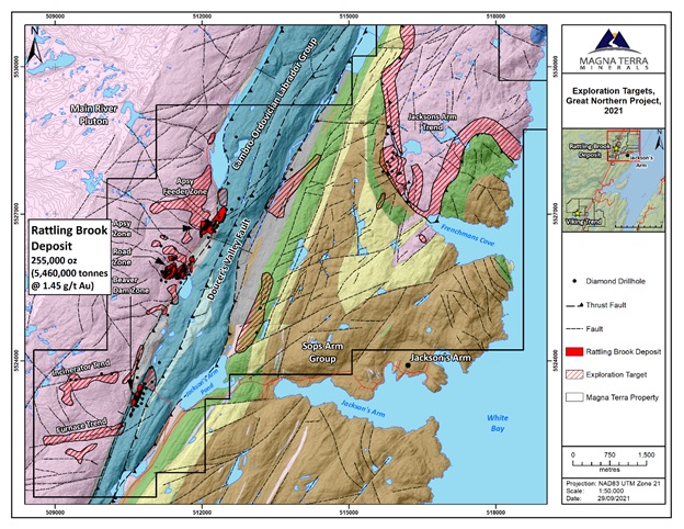
Exhibit C: Significant Gold Exploration Targets at the Rattling Brook Deposit and Jacksons Arm Trend.
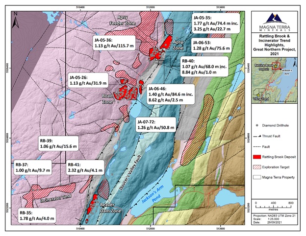
Exhibit D: Plan Map of Select Drill Intercepts (core length), Mineral Resource Areas and Exploration Targets, Rattling Brook Deposit Area, Great Northern Project.
SOURCE: Magna Terra Minerals Inc.