
Thursday, 27 January 2022 07:00 AM
Company Update
TORONTO, ON / ACCESSWIRE / January 27, 2022 / Anaconda Mining Inc. ("Anaconda" or the "Company") (TSX:ANX)(OTCQX:ANXGF) is pleased to announce that it has initiated an exploration program at its 100% owned Tilt Cove Gold Project, located within the Baie Verte Mining District, Newfoundland, approximately 45 kilometres by road from the Company's Pine Cove Mill and long-term tailings storage facility (Exhibit A). Anaconda has consolidated more than 11,000 hectares of prospective mineral lands including a significant property package covering 35 kilometres of high-potential strike length including the Nugget Pond Horizon, a geological unit that hosts the past producing, high-grade Nugget Pond Mine.
The winter exploration program will consist of a 100-line-kilometre ground Induced Polarization ("IP") geophysical survey and 4,000 metres of diamond drilling (the "Winter Exploration Program"). The IP geophysical survey is designed to locate anomalies analogous to the Nugget Pond Deposit to depths down to 250 metres, which have not been previously investigated at Tilt Cove. The Winter Exploration Program will also include 4,000 metres of diamond drilling at two target areas known as the Nugget Pond and Long Pond Target Areas. The drill program will include drilling from frozen ponds and will leverage improved access conditions at this time of year. The Winter Exploration Program is based on information gathered during the late summer and fall of 2021, a summary of which is provided below with remaining analytical results anticipated in Q1 2022.
Highlights of the Tilt Cove Gold Project and results to date include:
- Large land position that has been consolidated for gold exploration for the first time in 20 years with 35 kilometres of prospective strike;
- Includes the Nugget Pond Horizon, which hosts the past-producing high-grade Nugget Pond Mine that produced 168,748 ounces and an average grade of 9.85 grams per tonne ("g/t") gold;
- Significant high-grade historical and recent drill intercepts and the identification of 13 high-priority gold exploration targets including:
- 4.99 g/t gold over 4.0 metres, including 17.40 g/t gold over 1.0 metre in diamond drill hole EP-21-09 along the Red Cliff Horizon at East Pond;
- 8.82 g/t gold over 1.0 metre in historic diamond drill hole NBC-96-01 at East Pond;
- 1.74 g/t gold over 12.0 metres, including 11.43 g/t gold over 1.0 metre in diamond drill hole BC-21-05 at Betts Cove;
- 6.77 g/t gold over 5.0 metres in historic diamond drill hole BC-89-02 at Betts Cove;
- 11.20 g/t gold over 1.1 metres in historic diamond drill hole BC-89-01 at Betts Cove; and
- Recognition of several other favorable targets, including iron-rich sediments of the Red Cliff Horizon;
- Recognition of gold-rich environments in the hanging wall of past-producing copper mines, including the Tilt Cove and Betts Cove Mines;
- Intersection of high-grade copper mineralization at the Scarp Zone near the Tilt Cove mine
"We are pleased to begin the next phase of drilling at our Tilt Cove Gold Project, as well as initiating a geophysical survey to develop further targets at depths not yet explored in this area. The investment thesis at Tilt Cove is based on a 35-kilometre strike extent of highly prospective geological terrane adjacent to the Green Bay Fault, a crustal scale structure proximal and genetically linked to both the past-producing Nugget Pond and Hammerdown high-grade gold mines. Targets within the Tilt Cove Project are also immediately along strike from the past producing, high-grade Nugget Pond mine. This rich geological environment is located within trucking distance to the Company's Pine Cove Mill and long-term tailings facility, making the discovery of a high-grade gold deposit an immediate catalyst for growth. While we have immediate targets available for drill testing during the winter program, the IP geophysical survey is designed to identify currently unknown high-grade gold targets at depth in favorable geological environments. We believe this is an excellent opportunity to make the next high-grade gold discovery in Newfoundland."
~ Kevin Bullock, President and CEO, Anaconda Mining Inc.
Summer-Fall 2021 Exploration Program
The Tilt Cove Gold Project has several exploration targets in four main areas: the Nugget Pond, Long Pond, Betts Cove and Nippers Harbour Target areas (Exhibit B).
Work conducted in the summer and fall of 2021 at Tilt Cove focused on geochemical surveys and alteration studies at the Nugget Pond Target Area. Work included:
- Collection of 30 till samples at West Pond and the collection of 621 soil samples across the West Pond to East Pond area;
- Collection of 1,139 rock samples during a prospecting, mapping and a structural analysis of the property; and
- Review of historic core and sample collection for alteration studies including geochemistry on 905 samples collected for analysis.
At the Nippers Harbour Target Area exploration work focused on reconnaissance geochemical surveys as well as follow-up sampling and geological mapping of existing gold occurrences: Work included:
- Collection of 43 rock samples;
- Collection of 72 reconnaissance-style stream sediment samples;
- An airborne LiDAR survey to provide a detailed digital elevation model to aid in structural and glacial geological interpretation; and
- A desktop glacial geological study to better understand glacial ice flow directions and its significance for interpreting geochemical data.
Rock and soil samples were submitted to Eastern Analytical Limited for gold assay and multi-element ICP analysis. Till and stream sediment samples were shipped to Overburden Drilling Management Limited for processing of heavy mineral separates, including gold, which will then be sent to ActLabs Ltd. for gold fire assay and multi-element ICP analysis. Final analytical data for the summer and fall exploration program are expected tin the first quarter of 2022.
Winter 2022 Exploration Targets on the Tilt Cove Project
Nugget Pond Target Area
The Nugget Pond Target Area is a 7.5-kilometre zone along the Nugget Pond Horizon extending northeast from the Nugget Pond Gold Mine to the Tilt Cove Mine (Exhibit B). There are four key exploration targets that are prospective for Nugget Pond-style mineralization on the Property as follows:
East Pond Prospect - The East Pond Prospect comprises a minimum 800-metre long segment of the Nugget Pond Horizon beneath East Pond. Diamond drilling in 1997 and 1998 from the north side of East Pond intersected gold mineralization in the footwall of the Nugget Pond Horizon similar to footwall style mineralization at the Nugget Pond Mine. This suggests that the Nugget Pond Horizon above these holes may be mineralized and that these holes intersected northwest oriented mineralized structures like those at the Nugget Pond Mine. Recent drill testing of the Red Cliff Horizon at East Pond included an intersection of 4.99 g/t gold over 4.0 metres.
West Pond Prospect - The West Pond Prospect comprises a minimum 1.3-kilometre long target beneath West Pond that is marked by the continuation of the Nugget Pond Horizon northeast of the Nugget Pond Mine. The horizon outcrops on the east and west shores of the pond where gold mineralization has been sampled. Continuation of the horizon under the pond is inferred from combined magnetic and IP conductivity data. There is a strong combined till and soil anomaly that extends down ice (SE) from the Nugget Pond Horizon for at least 600 metres. The Nugget Pond Horizon in this area is associated with a break in the magnetic trend indicative of alteration and magnetic destruction associated with a cross-cutting northwest oriented fault, similar to that present at the Nugget Pond Mine. The combined soil geochemical and geophysical features make this an attractive target for follow up drilling testing.
Long Pond Target Area
The Long Pond Target Area is a 4.0-kilometre long zone that is located at the contact between ultramafic rocks of the Betts Cove Complex and younger Silurian felsic volcanic rocks of the Silurian Cape St. John Group (Exhibit B). The Long Pond Zone includes six gold (+/- copper) prospects over its strike length that include:
Long Pond Prospect - A zone of strongly silicified, hematized, carbonatized, brecciated ultramafic rock that is host to quartz stringers, veinlets and stockworks up with veins up to two metres wide. The mineralized zone is exposed over a 125 metre strike extent and is up to 35 metres wide. Grab samples from the prospect have returned assays up to 75.90 g/t gold with abundant visible gold. Historic drilling has returned assays of up to 21.5 g/t gold over 1.19 metres.
Long Pond West Prospect - This prospect comprises a quartz vein with grab samples assay up to 9.90 g/t gold and channel sampling returned assays of 1.52 g/t gold over 15 centimetres. A single drill hole testing the occurrence intersected 2.69 g/t gold over 1.12 metres. The prospect was discovered via follow-up of a till sample that assayed 83.90 g/t gold.
This news release has been reviewed and approved by Paul McNeill, P. Geo., VP Exploration with Anaconda Mining Inc., a "Qualified Person", under National Instrument 43-101 Standard for Disclosure for Mineral Projects.
All samples collected by Anaconda and the resultant composites referred to in this release were collected using QA/QC protocols including the regular insertion of certified standards and blanks within each sample batch sent for analysis and completion of check assays of select samples. Diamond drill core and percussion samples were analyzed for Au at Eastern Analytical Ltd. in Springdale, NL ("Eastern"), using standard fire assay (30 g) pre-concentration and Atomic Absorption finish methods. Eastern is a fully accredited firm within the meaning of NI 43-101 for provision of this service.
Historical grab and float rock samples and historical drill core samples are compiled from historic reports and data filed with the Department of Natural Resources, Newfoundland and Labrador. Sufficient work has not been completed by Anaconda geologists and QPs to verify the validity of these individual assays.
"Rock grab and float samples" are selected samples and are not necessarily representative of mineralization that may be hosted on the property.
ABOUT ANACONDA
Anaconda Mining is a TSX and OTCQX-listed gold mining, development, and exploration company, focused in the top-tier Canadian mining jurisdictions of Newfoundland and Nova Scotia. The Company is advancing the Goldboro Gold Project in Nova Scotia, a significant growth project subject to a positive Feasibility Study with Mineral Reserves of 1.15 million ounces of gold (15.80 million tonnes at 2.26 g/t gold), Measured and Indicated Mineral Resources inclusive of Mineral Reserves of 2.58 million ounces (21.6 million tonnes at 3.72 g/t gold) and additional Inferred Mineral Resources of 0.48 million ounces (3.18 million tonnes at 4.73 g/t gold) (Please refer to the report entitled "NI 43-101 Technical Report and Feasibility Study for the Goldboro Gold Project, Eastern Goldfields District, Nova Scotia", dated January 11, 2022). Anaconda also operates mining and milling operations in the prolific Baie Verte Mining District of Newfoundland which includes the fully permitted Pine Cove Mill, tailings facility and deep-water port, as well as ~15,000 hectares of highly prospective mineral property, including those adjacent to the past producing, high-grade Nugget Pond Mine at its Tilt Cove Gold Project.
FORWARD-LOOKING STATEMENTS
This news release contains "forward-looking information" within the meaning of applicable Canadian and United States securities legislation. Forward-looking information includes, but is not limited to, disclosure regarding the economics and project parameters presented in the PEA, including, without limitation, IRR, all-in sustaining costs, NPV and other costs and economic information, possible events, conditions or financial performance that is based on assumptions about future economic conditions and courses of action; the timing and costs of future development and exploration activities on the Company's projects; success of development and exploration activities; permitting time lines and requirements; time lines for further studies; planned exploration and development of properties and the results thereof; and planned expenditures and budgets and the execution thereof. Generally, forward-looking information can be identified by the use of forward-looking terminology such as "plans", "expects", or "does not expect", "is expected", "budget", "scheduled", "estimates", "forecasts", "intends", "anticipates", or "does not anticipate", or "believes" or variations of such words and phrases or state that certain actions, events or results "may", "could", "would", "might", or "will be taken", "occur", or "be achieved". Forward-looking information is based on the opinions and estimates of management at the date the information is made, and is based on a number of assumptions and is subject to known and unknown risks, uncertainties and other factors that may cause the actual results, level of activity, performance or achievements of Anaconda to be materially different from those expressed or implied by such forward-looking information, including the risks outlined in this news release, risks associated with the exploration, development and mining such as economic factors as they effect exploration, future commodity prices, changes in foreign exchange and interest rates, actual results of current production, development and exploration activities, government regulation, political or economic developments, environmental risks, permitting timelines, capital expenditures, operating or technical difficulties in connection with development activities, employee relations, the speculative nature of gold exploration and development, including the risks of diminishing quantities of grades of resources, contests over title to properties, and changes in project parameters as plans continue to be refined as well as those risk factors discussed in Anaconda's annual information form for the year ended December 31, 2020, available on www.sedar.com. Although Anaconda has attempted to identify important factors that could cause actual results to differ materially from those contained in forward-looking information, there may be other factors that cause results not to be as anticipated, estimated or intended. There can be no assurance that such information will prove to be accurate, as actual results and future events could differ materially from those anticipated in such information. Accordingly, readers should not place undue reliance on forward-looking information. The Company does not undertake to update any forward-looking information, except in accordance with applicable securities laws.
FOR ADDITIONAL INFORMATION CONTACT:
Anaconda Mining Inc.
Kevin Bullock
President and CEO
(647) 388-1842
[email protected]
Reseau ProMarket Inc.
Dany Cenac Robert
Investor Relations
(514) 722-2276 x456
[email protected]
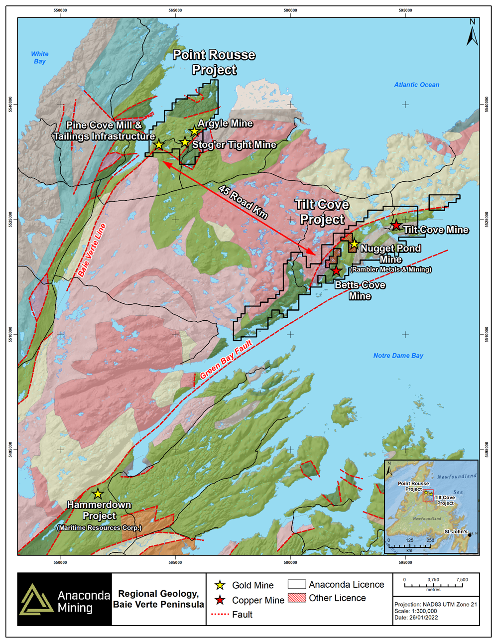
Exhibit A. A map showing the location of the Tilt Cove project relative to the Pine Cove Mill and Tailings infrastructure as well as other past producing mines in the region.
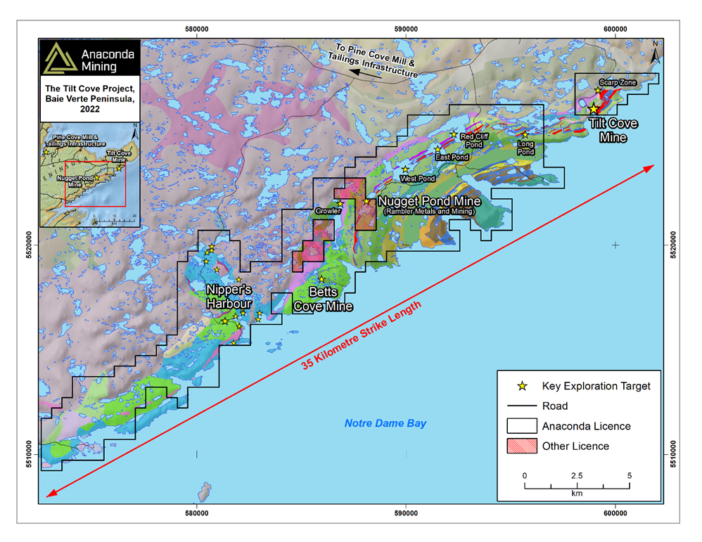
Exhibit B. A map showing the extents of the Tilt Cove Gold Project and the 35 kilometres of strike.
SOURCE: Anaconda Mining Inc.