


TORONTO, ON / ACCESSWIRE / September 7, 2021 / Magna Terra Minerals Inc. (the "Company" or "Magna Terra") (TSXV:MTT) is pleased to announce that it has completed a summer exploration program (the "Exploration Program" or "Program") at its 100% owned Great Northern and Viking Gold Projects ("Great Northern" and "Viking"), located in western Newfoundland. The purpose of the Exploration Program was to determine if existing mineralized trends continued along strike, or proximal, to known mineralization at surface. Specifically, the Program attempted to identify mineralization along strike from the 2.4-kilometre Jacksons Arm Trend (Exhibit A and B), the southern strike extent of the Rattling Brook Deposit (Exhibit C and D) and with additional work conducted at, and along strike from, Little Davis Pond at Viking (Exhibit E). The Program included systematic prospecting and geological mapping with attention paid to numerous geochemical and geophysical anomalies generated from previous exploration work conducted by the Company in 2020 and early 2021 and included the collection of 2,511 soil samples along strike from two mineralized trends (Exhibits B and D).
Highlights of the program to date include:
- Identification of an alteration zone, with anomalous gold, 2.0 kilometres along strike from the Jacksons Arm Trend potentially extending the Trend to 4.4 kilometres (Exhibit A);
- Collection of 1,424 soil samples south and north of the current known extents of the Jacksons Arm Trend where prospective rocks have been recognized;
- Staking of 20 additional claims covering 500 hectares of prospective rocks of the Sops Arm Group and along strike to the south of the Jacksons Arm Trend;
- Finding surface mineralization 1.3 kilometres southwest of the southern extent of the Rattling Brook Deposit (Exhibit C) and the collection of 1,087 soil samples (Exhibit D);
- Completion of a LiDAR survey over the Viking Project to assist with geological mapping, prospecting and the recognition of gold hosting structures - a theme of all mineralized zones with the Great Northern and Viking Projects; and
- Recognition of surface mineralization 2.0 kilometres southeast of the Little Davis Pond Prospect (Exhibit E).
The assays for the 2,511 soil samples collected at Rattling Brook will be reported once the data is received and reviewed.
"We continue to advance our work at Great Northern and Viking as planned. The summer Exploration Program was focused on testing the along strike, and proximal extents of surface mineralization encountered along several mineralized trends at Great Northern and Viking. The results to date indicate mineralized trends continue along strike and are open for expansion and discovery. We continue to be impressed by the scale and intensity of the alteration systems we are outlining at the projects and believe this scale is a primary indicator of the potential to host large gold deposits. Once we have the soil geochemistry in hand, we will be able to develop the next phase of exploration work, which we anticipate will include drill testing of these expanded mineralized trends."
~ Lew Lawrick, President and CEO, Magna Terra Minerals Inc.
Exploration Program Details
Prospecting and Geological Mapping
Reconnaissance-style prospecting, rock sampling and geological mapping were completed on the Great Northern and Viking Projects with a particular focus on areas more easily reached in the summer by use of ATV trails and roads. Prospecting resulted in the collection of 267 rock samples primarily focused on areas along strike of the Rattling Brook Deposit and the Jacksons Arm Trend as well as the Little Davis Pond area.
Prospecting was successful in locating zones of sulphide (Py, Cpy) bearing quartz veins and associated wallrock alteration (Fe-carbonate, sericite, Py) 2.0 kilometres along strike to the north of the Jacksons Arm Trend, 1.3 kilometres southwest of the Beaver Dam Zone Rattling Brook Deposit, and 2.0 kilometres southeast of the Little Davis Pond Prospect.
Highlight assays from rock grab and float samples** include:
- 0.25 grams per tonne ("g/t") gold from rock grab samples at the southern end of the Jackson's Arm prospect in quartz veins cutting tonalite;
- 4.8, 0.36, 0.35, 0.19 g/t gold from rock grab samples in altered granodiorite at individual localities north of the Road Zone resource;
- 0.65, 0.53, and 0.17 g/t gold from rock grab samples in altered granodiorite at two localities south of the Road Zone resource; and
- 0.12 g/t gold from rock grab samples in a quartz vein cutting quartzose sandstone at the Freeman Prospect, 2.0 km southeast of Little Davis Pond.
**Grab and float samples are selected samples and are not necessarily indicative of mineralization that may be hosted on the property.
Some follow-up prospecting was completed on the Apsy Feeder Zone, a northwest oriented fault splay extending from the Apsy Zone. Several historical hand-dug trenches expose the iron-carbonate+sericite altered granodiorite bedrock. The zone hosts 6 rock samples with gold grades above 1.0 g/t, and two samples with grades above 3.0 g/t gold. The highest-grade sample hosts 3.2 g/t gold. The Apsy Feeder Zone will be further assessed as a drill target for this fall as it possibly represents an extension to the Rattling Brook Deposit that has been previously untested.
Rock samples were submitted to Eastern Analytical Limited ("Eastern Analytical") for gold and multi-element ICP analysis.
Soil Sampling
Magna Terra completed a systematic geochemical program comprising primarily B-horizon soil sampling focused on an area along strike to the north and south of the Jacksons Arm Trend, where work from 2020 showed continuation of anomalous gold in soils and rock samples in these areas (Exhibit B). A total of 1,424 samples were collected in the Jacksons Arm Trend area along 100 metre spaced east-west oriented lines at 25 metre sample intervals. The survey was designed to follow-up and expand upon historical sampling in the area that outlines areas of anomalous gold-in-soils.
South of the Rattling Brook Deposit a total of 1,087 largely B-Horizon soil samples were collected along 100 metre spaced lines at 25 metre sample intervals (Exhibit D). Soil sampling was designed to cover the possible along strike extension south of the Beaver Dam Zone along the trace of the Doucer's Valley Fault and several east-west oriented fault splays that have potential to host gold mineralization. Similar east-west fault splays to the north host gold mineralization at the Incinerator Trail Zone.
Soil samples will be submitted to Eastern Analytical for gold and multi-element ICP analysis. Analytical results are pending and will be reported in a future news release.
LiDAR Survey
The Company contracted Leading Edge Geomatics of Fredericton, New Brunswick to complete an airborne Light Detection and Ranging ("LiDAR") survey over the Viking Project. The survey was designed to capture detailed topographic information that will aid in structural and glacial geological interpretation, in particular in helping to identify fault zones that are prospective for and linked to gold mineralization.
Claim Staking
The Company has expanded the Great Northern Project by staking an additional 20 claims in 1 mineral licence (032911M) covering 500 hectares. These mineral lands cover the southern, along strike, extension of the Jacksons Arm Trend in an area largely underlain by highly deformed rocks of the Sops Arm group volcanic and sediments (Exhibit B).
About the Great Northern and Viking Projects
The Great Northern and Viking Projects comprise two separate claim blocks (13,775 hectares) that are located near the communities of Sops Arm, Pollard's Point and Jackson's Arm, NL.
The Projects are centered along a 20-kilometre section of the Doucer's Valley Fault, a significant geological control on, and host to, several gold deposits and untested prospects, including the Rattling Brook and Thor Deposits, Jacksons Arm, Little Davis Pond, and Viking Trends and the Incinerator Trail Zone. Gold mineralization is hosted within a variety of rock types that include Precambrian or Ordovician granites, or younger volcanic and sedimentary rocks, typically along splays off the Doucer's Valley Fault. Alteration consists of mesothermal style quartz ± iron carbonate ± sulfide veins and stockworks with 2 to 5% total sulfides consisting of pyrite, galena, chalcopyrite or sphalerite, and locally show trace amounts of visible gold.
Magna Terra is focusing on the Jacksons Arm Trend, which is host to a 2.4 kilometre long by 40- to 400-metre-wide continuous alteration zone, that is controlled by a north-south striking fault. The fault extends immediately to the north along strike with similar repeating fault zones to the east outlining a potential strike extent of an additional 4 kilometres. A recent phase 1 drilling program (see news release dated February 18, 2021) by the Company at the Jacksons Arm Trend intersected broad zones of alteration and gold mineralization in each drill hole outlining a large fertile gold-bearing alteration system along at least a 300 metre section of the larger Jacksons Arm Trend with assays including:
- 4.67 g/t gold over 0.5 metres (73.5 to 74.0 metres) in drill hole JA-20-01;
- 3.84 g/t gold over 0.5 metres (46.5 to 47.0 metres) in drill hole JA-20-07; and
- 2.01 g/t gold over 1.0 metre (22.5 to 23.5 metres) in drill hole JA-20-08.
Highlights of previous surface grab samples** include:
- Assays up to 20.20 g/t gold and 1,232 g/t silver at the Boot N' Hammer Prospect;
- Assays up to 56.70 g/t gold and 2.75 ounce per tonne silver at the Stocker Prospect;
- Assays up to 7.20 g/t gold at the Shrik Prospect; and
- Assays up to 13.60 g/t gold at the 954 Prospect.
- An Inferred Mineral Resource Estimate^ of 5,460,000 tonnes at an average grade of 1.45 g/t gold containing 255,000 contained ounces at a cut-off grade of 1.0 g/t gold at the Rattling Brook Deposit; and
**Grab samples are selected samples and are not necessarily indicative of mineralization that may be hosted on the property.
The Little Davis Pond Trend is underlain by strongly deformed and altered Silurian volcanic and sedimentary rocks that are host to a 1.4-kilometre-long geochemical anomaly (soil assays up to 530 ppb gold, and rock assays up to 22.15 g/t gold) from historic sampling.
The Incinerator Trail Zone has been tested by four reconnaissance-style diamond drill holes in the 1980s and returned assays of 1.78 g/t gold over 4.0 metres (hole RB-35) and 2.30 g/t gold over 4.05 metres (hole RB-41).
The Viking Trend is host to a 3+ kilometre long by up to 40-metre-wide deformation and alteration zone with gold grades of 0.45 g/t gold over 20.0 metres in hole VK-16-151, 0.37 g/t gold over 16.5 metres in hole VK-11-125, as well as local high grades as indicated by 7.43 g/t gold over 1.0 metre in hole VK-16-155.
The Great Northern and Viking Projects are host to significant Current and Historic Mineral Resources, including:
- An Historical Indicated Mineral Resource^^ of 937,000 tonnes at an average grade of 2.09 g/t gold containing 63,000 ounces of gold plus an Historical Inferred Mineral Resource of 350,000 tonnes at an average grade of 1.79 g/t gold containing 20,000 ounces of gold at a cut-off grade of 1.0 g/t gold at the Thor Deposit.
Mineral Resources are not Mineral Reserves and do not have demonstrated economic viability. All Mineral Resource Estimates were prepared in accordance with NI 43-101 and the CIM Standards (2014). Please refer to the NI 43-101 Technical Report with effective date January 23, 2019 by Harrington and Cullen (2019) as detailed below for the Great Northern Project and the NI 43-101 Technical Report with effective date August 29, 2016 by Copeland et al. (2016). An Independent Qualified Person has not carried out sufficient work to classify the Thor Historical Mineral Resource Estimate as current and Magna Terra is not considering this Mineral Resource Estimate to be current. Magna Terra considers the Thor Deposit to have potential for expansion that will be addressed by the Company in future exploration programs. See further details on Technical Reports below.
Pandemic Considerations
The Company has critically considered logistical matters given the ongoing COVID-19 pandemic, to ensure that this Exploration Program and all future programs are executed in a way that ensures the absolute health and safety of our personnel, contractors, and the communities where we operate.
Qualified Person and Technical Reports
This news release has been reviewed and approved by David A. Copeland, P. Geo., Chief Geologist with Anaconda Mining Inc., a "Qualified Person", under National Instrument 43-101 - Standard for Disclosure for Mineral Projects.
Rock samples were analyzed for gold at Eastern Analytical Ltd. in Springdale, NL ("Eastern"), using standard fire assay (30 g) pre-concentration and Atomic Absorption finish methods. Eastern is a fully accredited firm within the meaning of NI 43-101 for provision of this service.
"Grab samples" are selected samples and are not necessarily indicative of mineralization that may be hosted on the property.
^The Mineral Resource Estimate quoted in this press release regarding the Great Northern Project refers to the technical report: "NI 43-101 Technical Report and Updated Mineral Resource Estimate on the Rattling Brook Gold Deposit, Great Northern Project, White Bay Area, Newfoundland, Canada", (the "Great Northern Report") with an effective date of January 23, 2019, and authored by Matthew Harrington, P.Geo. (Independent Qualified Person) and Michael Cullen, P.Geo. (Independent Qualified Person).
^^The Historical Mineral Resource Estimate quoted in this press release regarding the Viking Project (Thor Deposit) is taken from the technical report: "NI 43-101 Technical Report And Mineral Resource Estimate For The Thor Deposit, Viking Project, White Bay Area, Newfoundland and Labrador, Canada, Latitude 49o 42′ N Longitude 57o 00′ W" prepared for Anaconda Mining Inc. by David A. Copeland, P.Geo., Dr. Shane Ebert, P. Geo. and Gary Giroux, P. Eng. M.ASc., August 29, 2016. An Independent Qualified Person has not carried out sufficient work to classify the Thor Historical Mineral Resource Estimate as current and Magna Terra is not considering this Mineral Resource Estimate to be current. Magna Terra considers the Thor Deposit to have potential for expansion that will be addressed by the Company in future exploration programs.
About Magna Terra
Magna Terra Minerals Inc. is a precious metals focused exploration company, headquartered in Toronto, Canada. Magna Terra owns three district-scale, advanced gold exploration projects in the world class mining jurisdictions of New Brunswick and Newfoundland and Labrador. Further, the Company maintains a significant exploration portfolio in the province of Santa Cruz, Argentina which includes its precious metals discovery on its Luna Roja Project, as well as an extensive portfolio of district scale drill ready projects available for option or joint venture.
Forward Looking Statements
Neither the TSX Venture Exchange nor its Regulation Services Provider (as that term is defined in the policies of the TSX Venture Exchange) accepts responsibility for the adequacy or accuracy of this release.
Cautionary Statements Regarding Forward Looking Information
Some statements in this release may contain forward-looking information. All statements, other than of historical fact, that address activities, events or developments that the Company believes, expects or anticipates will or may occur in the future (including, without limitation, statements regarding potential mineralization) are forward-looking statements. Forward-looking statements are generally identifiable by use of the words "may", "will", "should", "continue", "expect", "anticipate", "estimate", "believe", "intend", "plan" or "project" or the negative of these words or other variations on these words or comparable terminology. Forward-looking statements are subject to a number of risks and uncertainties, many of which are beyond the Company's ability to control or predict, that may cause the actual results of the Company to differ materially from those discussed in the forward-looking statements. Factors that could cause actual results or events to differ materially from current expectations include, among other things, without limitation, failure to establish estimated mineral resources, the possibility that future exploration results will not be consistent with the Company's expectations, changes in world gold markets or markets for other commodities, and other risks disclosed in the Company's public disclosure record on file with the relevant securities regulatory authorities. Any forward-looking statement speaks only as of the date on which it is made and except as may be required by applicable securities laws, the Company disclaims any intent or obligation to update any forward-looking statement.
FOR FURTHER INFORMATION PLEASE CONTACT:
Magna Terra Minerals Inc.
Lewis Lawrick
President and CEO, Director
647-478-5307
Email: [email protected]
Website: www.magnaterraminerals.com
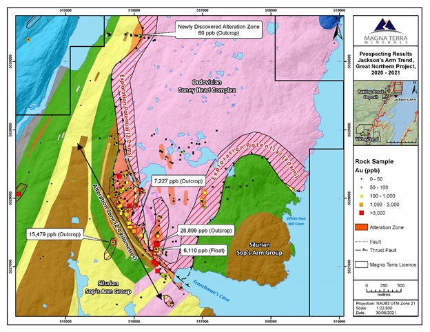
Exhibit A: Rock Samples (historic and current) collected from the 2.4 kilometre long Jacksons Arm Trend showing expansion of the alteration zone to the north along strike.
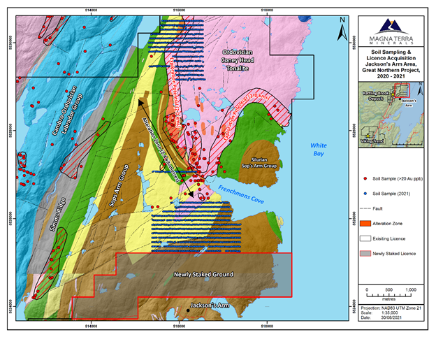
Exhibit B: Soil Samples collected to the North and South of the 2.4 kilometre long Jacksons Arm Trend.
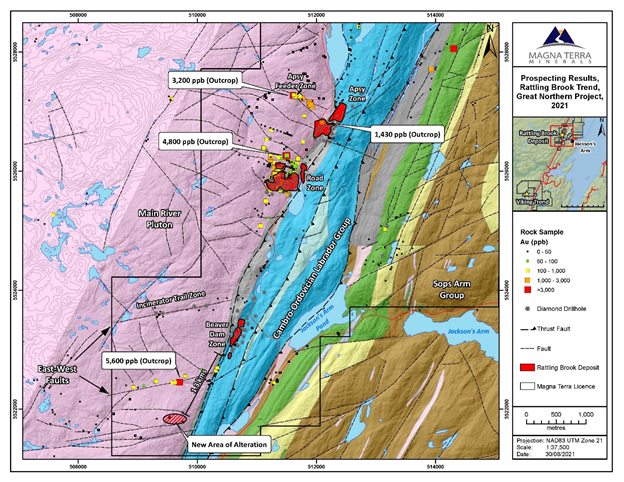
Exhibit C: Rock Samples (historic and current) collected from the Rattling Brook Deposit showing expansion of the alteration zone to the south along strike of the Beaver Dam Zone.
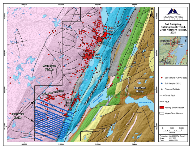
Exhibit D: Soil Samples collected to the South of the Beaver Dam Zone, Rattling Brook Deposit.

Exhibit E: Soil and Rock Samples (historic and current) at Little Davis Pond Trend, Viking Project, including new zone of alteration discovered at Freeman's Prospect.
SOURCE: Magna Terra Minerals Inc.