


THUNDER BAY, ON / ACCESSWIRE / June 7, 2021 / Wolfden Resources Corporation (TSXV:WLF) ("Wolfden" or the "Company") is pleased to report some positive drill results from a 5-hole, 2,300 metre winter diamond drilling program on is wholly owned Rice Island Nickel-Copper-Cobalt-Platinum Group Elements Project in Snow Lake, Manitoba.
- Three of the four holes that targeted the nickel-rich Keel and Feeder Zones intersected strong mineralization with nickel equivalent intercepts including 9 metres at 1.20% and 14 metres at 0.80% and 2 metres at 1.30%.
- The fourth hole passed below the east-plunging mineralization, just missing a historic intercept of 0.73% NiEq2 over 25.84 metres, which strongly suggests that the Keel Zone extends further down plunge to the East below 500 metres from surface.

"The drill holes returned assay results similar to what was expected and further increased our confidence in the deposit model, which supports more drilling to follow the plunge of the Keel to depth, to test the limbs of the Keel and to trace the Feeder Zone to depth." stated Don Dudek V.P Exploration for Wolfden. "It must also be emphasized that the Keel limbs are near vertical, that they increase in length when we follow the Keel to depth and would be cost effective to mine if shown to be economic."
One of the holes (RI21-41) targeting a deeper section of the keel zone passed below the east-plunging mineralization, just missing a historic intercept that yielded 0.73% NiEq2 over 25.84 metres (see figure ), Down hole geophysics was performed on this hole and indicates the potential for mineralization, however, there was not sufficient time to drill test this target due to the warming winter conditions and the need to demobilize the drill from the ice for spring break-up. Additional holes had been planned to test the Feeder Zone, at depth, down plunge where better widths and grades were previously intersected (0.94% NiEq2 over 12.4 metres - 5.5 metres true width) and nearby untested conductive zones. Further drilling of the zone down plunge and of both limbs on either side of the keel is definitely warranted (see Figure) and will be carried out in the next program. The drill program was funded in part with the support of a $230,000 grant from the Manitoba Government Mineral Development Fund.
The last hole of the program tested a regional airborne conductor and magnetic target over one kilometre to the northwest from the Rice Island zone on the shore of Lake Wekusko. Although the target proved to be a 138 metre-long intersection of mafic sediments with approximately 40% sulphides (pyrite and pyrrhotite) it did not return any significant values of precious metals.
The last hole of the program tested a regional airborne conductor and magnetic target over one kilometre to the northwest from the Rice Island zone on the shore of Lake Wekusko. Although the target proved to be a 138 metre-long intersection of mafic sediments with approximately 40% sulphides (pyrite and pyrrhotite) it did not return any significant values of precious metals.
The Keel Zone -Principle Ni-rich mineralization
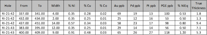
Holes RI-20-42 and RI-20-43 tested a 150-metre gap in the Keel Zone. A summary of assay results are as follows:
Hole RI21-41, was drilled to test near the base of the Keel Zone at approximately 475 metres depth. This hole missed the gabbro host intrusion and the deepest historic intercept of 0.73% NiEq2 over 25.8 metres (15.9 metres true thickness). Borehole electromagnetic data (BHEM) indicates a strong off-hole anomaly above the hole at 300 metres down the hole. The most likely source of this anomaly is the relatively undrilled south limb of the Keel Zone. A second, very strong, off-hole anomaly was encountered at the end of the hole, well past the target depth. The cause of the anomaly is not known and could be a more conductive portion of the Feeder Zone, a graphitic horizon, or, some as of yet, undiscovered conductive zone.
Hole RI21-42, is Wolfden's deepest intersection on the Keel Zone to date at 440 metres. This hole returned 0.80% NiEq2 over 14-metres (true width 9.4 metres), including a 4-metre wide zone returning 1.83% NiEq2. As expected, the highest grade NiEq2 mineralization lies at the base of the Keel Zone and grades upward into first blebby and then disseminated sulphide Figures 1-3). As well as intersecting the near the base of the U-shaped Keel zone, this hole also intersected the southern limb of the mineralization, approximately 100 metres shallower with an intercept of 0.53% NiEq2 over 4 metres (1.8 metres true width). This shallower intercept suggests potential to discover up-dip extensions to the Keel zone, in an area that has only been occasionally tested. Two BHEM anomalies were identified from this hole (see Figure 2.), the first being a strong anomaly at 415 metres above the hole, indicating a more conductive portion of the Keel Zone and the second, a very strong anomaly with good extent, at 455 metres, which could again indicate a more conductive portion of the Keel Zone and likely extensions to the Keel Zone, which is expected. These will be followed-up in the next round of drilling.
Hole RI21-43, intersected the Keel Zone 50 metres from the intercept in hole RI21-42 (Figures 1 and 4). This hole returned, a narrower, but higher-grade intercept of 1.20% NiEq2 over 9 metres (5.3 metres true width) and, an adjacent blebby to disseminated sulphide zone that returned 0.50% NiEq2 over 12 metres (7.1 metres true width, includes 3 metres grading 0.80% NiEq2). No BHEM surveys were completed down this hole.
The Feeder Zone - Feeder to the Keel Zone
Hole RI-21-40 was drilled to test a shallow portion of the Feeder Zone, the principal conduit of the Keel Zone mineralization (Figures1 and 2), and to test the top of a conductive zone indicated by surface EM data. This hole intersected a 3-metre-wide zone estimated to contain 5-10% combined millerite (mineral containing approximately 65% nickel) and associated pyrrhotite/pentlandite (mineral containing 30-35% nickel), of which 2 metres (1.13 metres true thickness), returned an intercept of 1.30% NiEq2 (0.74% Ni, 0.82% Cu, 0.07% Co, 79 ppb Au, 116 ppb Pd and 44 ppb Pt). This hole also intersected thermal alteration (silicified) zones beyond the Feeder Zone that may be indicative of additional mineralization nearby. Samples from the alteration zones returned low, but anomalous values in Au (to 21 ppb), Cu (to 142 ppm) and Zn (to 249 ppm).
A borehole electromagnetic (BHEM) survey of the hole returned a moderate strength off-hole at 90 metres, below and right of the hole. It seems likely that the BHEM anomaly is seeing a more conductive portion of the Feeder Zone, a bit farther down-dip. A second, strong anomaly was picked up at 140 metres down the hole. It is modelled below and right of the hole as well. This could also be related to a more conductive portion of the Feeder Zone, just a bit deeper.
The Regional Target
Hole RI-21-44 was drilled approximately 1 km west of the Rice Island deposit to test an airborne conductor and coincident magnetic target that occurs close to the main contact between the Wekusko Lake sediments and the Snow Lake volcanic belt. The hole intersected 138-metre long zone with approximately 40% sulphides (pyrite and pyrrhotite) within a quartz veined graphitic sedimentary host rock. Select samples were collected of the sulphidic sediments, with 2, one-metre wide samples returning 0.13% Zn and 0.21% Zn along with anomalous gold (to 22 ppb), Cu (to 298 ppm), Mo (to 127 ppm), Ni (to 209 ppm) and V (to 0.15%). This anomalous element assemblage suggests a sedimentary source environment, which has potential for the discovery of economic mineralization similar to those mined in China and documented in several sulphide-bearing black shale environments. A follow-up review of the drill core is planned to determine if additional sampling is required and if the samples should be analyzed for platinum as well.
About the Rice Island Deposit
The Rice Island Ni-Cu-Co-PGE sulphide deposit is comprised of a ‘keel' of higher-grade mineralization where previous drilling returned intercepts of up to 14.7 metres grading 3.63% nickel, 1.13% copper, 0.12% cobalt (March 22, 2016, true width approx. 5m) and a ‘feeder-dyke-type' zone that returned intercepts of up to 21.1 metres of 2.4% nickel, 1.3% copper and 0.16 g/t PGE2 (April 12, 2016, true width approx. 10.6m). A historical inferred mineral resource (non 43-101 compliant) was reported as 5.5 million tonnes at a grade of 1.1% nickel, 0.7% copper and 0.07% cobalt1. The Keel Zone has been traced for 600 metres and remains open down-plunge while the Feeder Zone is open along strike and at depth. The Feeder Zone was not included in the historical inferred resource.
The Next Drill Program
Follow-up drilling is warranted pending the completion of modelling and drill permitting. A summer drill program is currently under consideration and pending the availability of the required equipment. The obvious targets to be tested include the depth extension of the Keel Zone and its north and south limbs, the down plunge extension of the Feeder Zone and several other, untested geophysical targets and reported intersections of ultramafic rocks, with associated conductive zones.
QA/QC
Wolfden adheres to strict Quality Assurance and Quality Control protocols including routine insertion of blanks and certified reference standards in each sample batch of drill core that is sent to the lab for analyses. During this program, assay standards were inserted every 18 samples, blanks every 13.5 samples and duplicates every 21.6 samples. Drill core samples are split in half using a diamond saw with one half saved for reference and the other half shipped via secure transport to Activation Laboratories sample preparation facility in Thunder Bay, Ontario. All samples returned acceptable blank analyses and 4 of the standards returned values within 2 SD and 2 samples returned Ni values off by just over 2SD, but, were deemed acceptable. Core samples are analyzed for nickel, copper and cobalt utilizing sodium peroxide fusions (lab code FUS_Na2O2). Gold, platinum and palladium is analyzed by fire assay (30 g) utilizing AA finish (Code 1A2).
About Wolfden
Wolfden is an exploration and development company focused on high-margin metallic mineral deposits including base, precious and strategic metals. Its wholly owned Pickett Mountain Project is one of the highest-grade polymetallic projects in North America (Zn, Pb, Cu, Ag, Au). This relatively advanced project in northern Maine is well-located near excellent infrastructure that will support near term development as detailed in a Preliminary Economic Assessment date September 14, 2020.
For further information please contact Ron Little, President & CEO, at (807) 624-1136 or Rahim Lakha, Corporate Development at (416) 414-9954.
The information in this news release has been reviewed and approved by Don Dudek, P. Geo., VP Exploration and Ron Little P.Eng., President and CEO, who are Qualified Persons' under National Instrument 43-101.
1The potential tonnage and grade of the historical resource is conceptual in nature. There has been insufficient exploration of this deposit to define a Mineral Resource and it is uncertain if further exploration will result in the historical resource being delineated as a Mineral Resource
2 Nickel Equivalent (%NiEq) calculated using nickel price of US$ 7.70/lb, copper price of US$3.00/lb, cobalt price of US$20/lb, gold price of US$1,500/oz, palladium price of US$ 1,500/oz and platinum price of US$ 1,500/oz.
Cautionary Statement Regarding Forward-Looking Information
This press release contains forward-looking information (within the meaning of applicable Canadian securities legislation) that involves various risks and uncertainties regarding future events. Such forward-looking information includes statements based on current expectations involving a number of risks and uncertainties and such forward-looking statements are not guarantees of future performance of the Company, and include, without limitation, metal price assumptions, cash flow forecasts, projected capital and operating costs, metal or mineral recoveries, mine life and production rates, and other assumptions used in Preliminary Economic Assessment dated September 14, 2020, information about future activities at the Pickett Mountain Project that include plans to complete additional drilling and pre-permitting (rezoning petition), the results of the Preliminary Economic Assessment dated September 14, 2020, the potential upside of the Pickett Mt. Project, and the timing and completion of drill programs in Maine, Manitoba and New Brunswick and the respective drill results. There are numerous risks and uncertainties that could cause actual results and the Company's plans and objectives to differ materially from those expressed in the forward-looking information in this news release, including without limitation, the following risks and uncertainties: (i) risks inherent in the mining industry; (ii) regulatory and environmental risks; (iii) results of exploration activities and development of mineral properties; (iv) risks relating to the estimation of mineral resources; (v) stock market volatility and capital market fluctuations; and (vi) general market and industry conditions. Actual results and future events could differ materially from those anticipated in such information. This forward-looking information is based on estimates and opinions of management on the date hereof and is expressly qualified by this notice. Risks and uncertainties about the Company's business are more fully discussed in the Company's disclosure materials filed with the securities regulatory authorities in Canada at www.sedar.com. The Company assumes no obligation to update any forward-looking information or to update the reasons why actual results could differ from such information unless required by applicable law.
Neither TSX Venture Exchange nor its Regulation Services Provider (as that term is defined in the policies of the TSX Venture Exchange) accepts responsibility for the adequacy or accuracy of this release.
Figure 1. Rice Island Drill Hole Plan on Airborne Geophysics
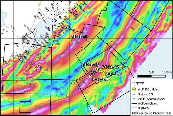
Figure 2. Rice Lake Deposit Model 3D View - Keel, in red plunges steep east, Feeder Zone is tan-colored

Figure 3. Rice Lake Section 301+00E, Drill hole RI21-42
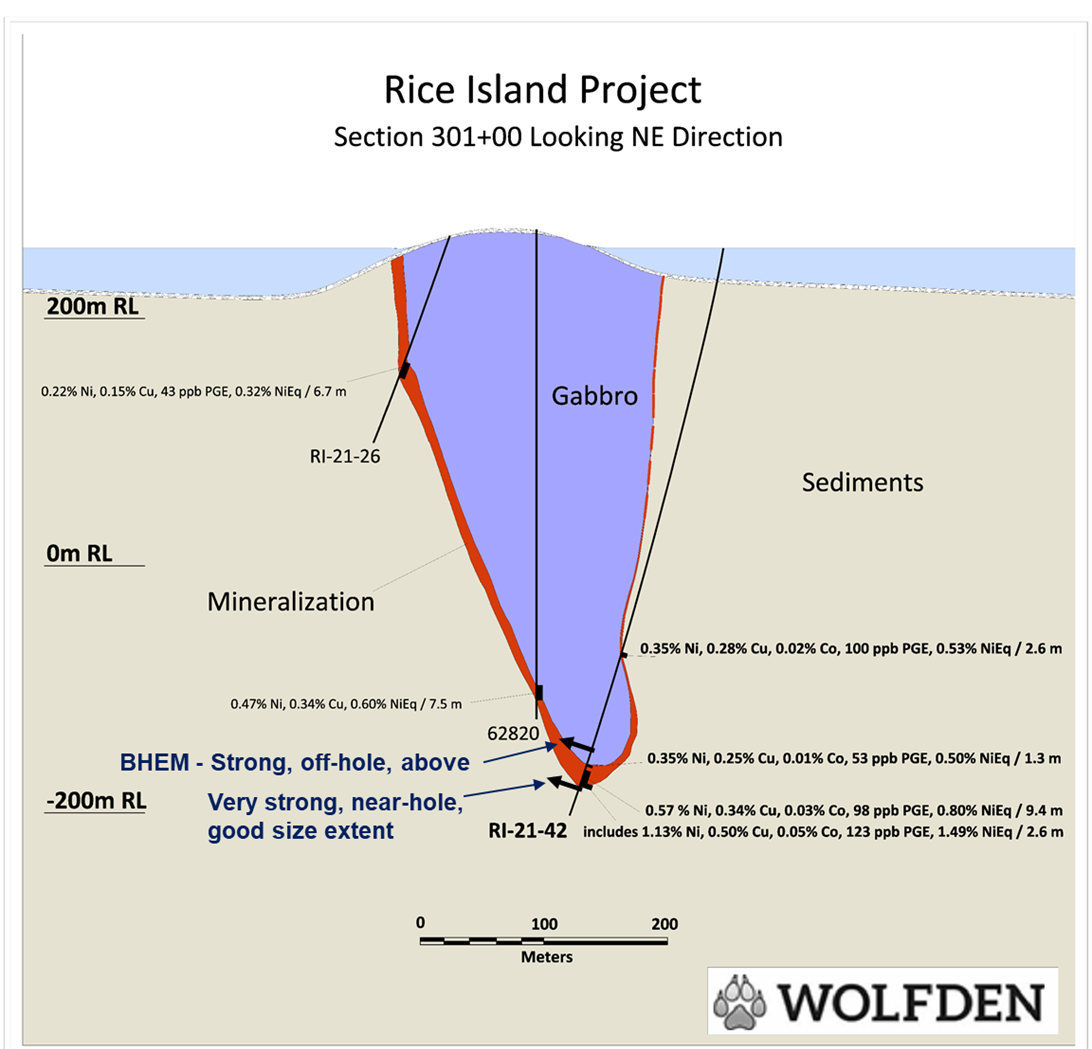
Figure 4. Rice Lake Section 279+50E, Drill hole RI21-43
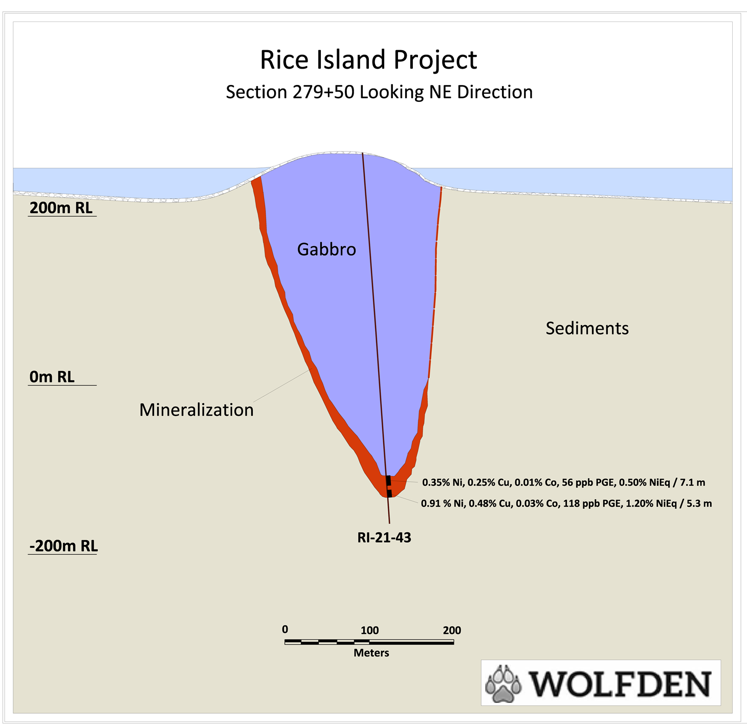
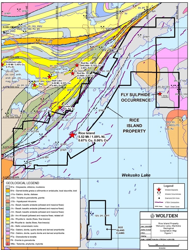
Figure 5. Rice Island Regional Geology Map and Wolfden Landing Holdings (black outline)
SOURCE: Wolfden Resources Corporation