Monday, 19 April 2021 06:30 AM
Company Update
SUDBURY, ON / ACCESSWIRE / April 19, 2021 / Northern Superior Resources ("Northern Superior" or the "Company") (TSXV:SUP)(OCTQB:NSUPF) is pleased to announce that it has expanded its previously announced 10,000 meter ("m") core drill program on its 100% owned Lac Surprise property (see Northern Superior press release, March 15, 2021). The expanded Phase II drill program has been increased to a minimum of 13,000m, and will consist of two stages.
Stage 1, expanded to 8,000m, is designed to better define and expand the newly discovered Falcon Gold Zone, believed to be the western extension of the neighboring IAMGold/Vanstar's Nelligan gold deposit located approximately 2.4 kilometers ("km") to the east with an inferred resource* of 3.2 million ounces at 1.02 g/t gold ("Au") (see Figure 1).
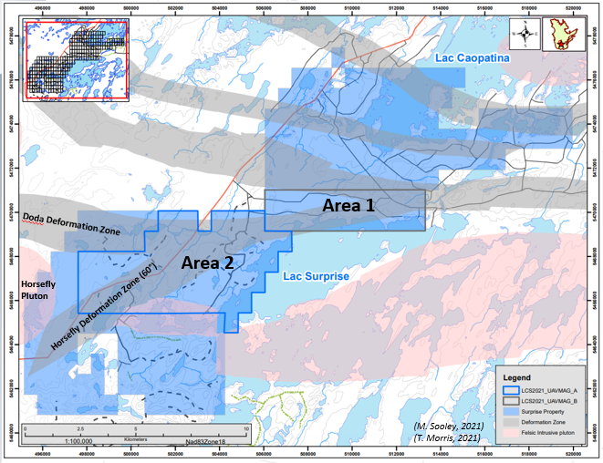
Stage 2, consisting of approximately 5,000m, is designed to test three early-stage gold targets west of Target 1; Target 3; the Fox Gold showing and the Confluence Area (see Figure 2).
Stage 1: Target 1, Better Defining the Falcon Gold Zone
Based on the progress of the drill program to date the board has approved an expansion of the Stage 1 drill program on the Falcon Zone to 27 holes over 8,000m from its prior 16 holes over 5,000m. Eight holes (2,591m) of the now expanded 8,000m Stage 1 program have been completed. Five of the first eight holes have been processed with 1,134 samples submitted for assays, with material from another two holes expected to be delivered to the lab by the end of next week. These first eight holes cover a strike length of 450m from the property boundary near the first discovery hole of the Falcon Gold Zone (LCS20-13, 1.07 g/t gold equivalent ("AuEq")** over 35.5m with a high-grade interval of 8.22 g/t AuEq over 2.6m) to 150m west of the second discovery hole (LCS19-005ext., 1.55 g/t AuEq over 44.9m, including 3.82 g/t AuEq over 15m). Although most of these holes are relatively shallow (~250m), one deep hole has been completed (375m) while a second deep hole of (350m) is in progress currently. The expanded 27 hole program will test a potential strike length of approximately 900m.
Dr. T.F. Morris, President and CEO states: "We are very pleased with the drill progress made to date at Target 1, having learned much about the Falcon Gold Zone from the Fall 2020 drill program we have been able to apply this knowledge to the current program. The expanded Phase II drill program of 13,000 meters will allow us to fully define the full potential of this exciting new discovery for our shareholders.
We are also very excited to share details of our plans for Stage 2 of this program, having completed a thorough evaluation of highly prospective targets at Target 3, the Fox Gold Zone and the Confluence Area. In addition, initiating a drone magnetic survey over the central part of the property will provide high quality magnetic data, the same type of magnetic data used to assist in discovering the Falcon Gold Zone at Target 1 and defining the geophysical parameters associated with Target 3. This data will go a long way to refining drill targets in the Confluence area and the area directly to the south and west.
We look forward to sharing the progress and the results of these various initiatives on the Lac Surprise property as assays become available."
Stage 2: Target 3, Falcon Showing and the Confluence Area
Target 3
Target 3 is a compelling, large geophysical target located 7km west of the Nelligan gold deposit (see Figure 2). The geophysical signature of this target consists of a number of similarities to the Nelligan geophysical signature that led to the discovery of the Falcon Gold Zone. The geophysical attributes include:
- A large, deeply rooted intrusion;
- Associated with 60° faults; and
- Associated large areas magnetic lows suggesting areas of silicification and alteration leading to magnetic destruction. There are three such large areas identified to the southeast (~4.0 x 1.0kms), northeast (~2.0 x 2.0kms) and northwest (~1.0km x 1.0km) of the proposed intrusion (Figure 3).
Our Initial Drilling on Target 3 will focus on the largest target to the southeast (4.0 x 1.0 kms) and will be tested with 3 core drill holes, each 400m long.
Fox Gold Showing
The Fox gold showing is located along the southwest part of the southeast area of Target 3. Unlike the targets associated with Target 3, the Fox showing is associated with a high magnetic signature suggesting an association with a more iron-rich environment. Gold-bearing material associated with this showing was collected from two channel samples (up to 6.76 g/t Au over 1.0m: Fox North showing; up to 2.95 g/t Au over 1.0m: Fox Showing) and grab samples from SOQUEM trenches (up to 900 ppb Au; ref. GM49908)(see Figure 4).
Four drill holes for a total of approximately 1,000m is currently proposed to test this target.
Confluence Area
The Confluence is an area where two prominent deformation zones converge (Remick and Doda: the "Confluence Area"; see Figure 2). This area contains a prominent gold grain dispersal train (maximum 49 gold grains, 10 kilogram ("kg") till sample). A 10kg stream sediment sample just west and at the intersection of two faults yielded 107 gold grains. This area also has a gold showing with a grab sample that assayed 1.35 g/t Au.
To test the prospectivity for gold mineralization in this area, three targets were selected based on a careful evaluation of the Company's Induced Polarization geophysical data, distribution of gold grain data and historical drilling (see Figure 5).
These targets will be tested with 5 drill holes, each 300m in length.
Drone Magnetic Survey
Northern Superior is also pleased to announce that it has initiated a 954 line-kilometer, 50m spaced, drone magnetic survey over the central part of the property (see Figure 6). The geophysical product derived from this program will be the same high-quality data used to identify the geophysical properties associated with the Falcon Gold Zone discovered in Target Area 1 and the geophysical properties associated with Target 3. The data will also be used to refine targets in the Confluence Area and the area to the south and southwest of the Confluence Area.
* Reference for IAMGOLD/Vanstar's Nelligan 3.2MM Inferred Gold Resource: "Carrier, Alain (M.Sc., P.Geo); Nadeau-Benoit, Vincent (P.Geo); Fauvre, Stéphane (PhD., P.Geo). October 22, 2019. NI 43-101 Technical Report and Initial Resource Estimate for the Nelligan Project, Québec, Canada."
** Gold equivalent grades calculated based on a 75 Au:Ag factor ratio.
Qualified Person
Michel Leblanc (P.Geo.) is a Qualified Person ("QP") within the meaning of National Instrument 43-101. Mr. Leblanc has reviewed, and approved information disclosed in this press release. Michael Leblanc, who is also a Qualified Person ("QP") will be overseeing the core drill program.
Note to readers: Mineralization hosted on adjacent and/or nearby properties is not necessarily indicative of mineralization hosted on the Company's property.
About Northern Superior Resources Inc.
The Lac Surprise gold property is one of three key mineral properties 100% owned by Northern Superior Resources. The other two properties (TPK and Croteau Est) also represent regional scale exploration opportunities (see Northern Superior Corporate Presentation, www.nsuperior.com).
Northern Superior is a reporting issuer in British Columbia, Alberta, Ontario and Québec, and trades on the TSX Venture Exchange under the symbol SUP, and the OTCQB Venture Market under the symbol NSUPF.
For Further Information
Please refer to Northern Superior news available on the Company's website (www.nsuperior.com) and on SEDAR (www.sedar.com) or contact:
Thomas F. Morris P.Geo., PhD., FGAC
President and CEO
Tel: (705) 525 ‐0992
Fax: (705) 525 ‐7701
e‐mail: [email protected]
Cautionary Note Regarding Forward-Looking Statements
This Press Release contains forward-looking statements that involve risks and uncertainties, which may cause actual results to differ materially from the statements made. When used in this document, the words "may", "would", "could", "will", "intend", "plan", "anticipate", "believe", "estimate", "expect" and similar expressions are intended to identify forward-looking statements. Such statements reflect our current views with respect to future events and are subject to such risks and uncertainties. Many factors could cause our actual results to differ materially from the statements made, including those factors discussed in filings made by us with the Canadian securities regulatory authorities. Should one or more of these risks and uncertainties, such actual results of current exploration programs, the general risks associated with the mining industry, the price of gold and other metals, currency and interest rate fluctuations, increased competition and general economic and market factors, occur or should assumptions underlying the forward looking statements prove incorrect, actual results may vary materially from those described herein as intended, planned, anticipated, or expected. We do not intend and do not assume any obligation to update these forward-looking statements, except as required by law. Shareholders are cautioned not to put undue reliance on such forward-looking statements.
Neither the TSX Venture Exchange nor its Regulation Services Provider (as that term is defined in the policies of the TSX Venture Exchange) accepts responsibility for the adequacy or accuracy of this release.
Figure 1: Phase II Stage I core drill plan, Target Area 1.
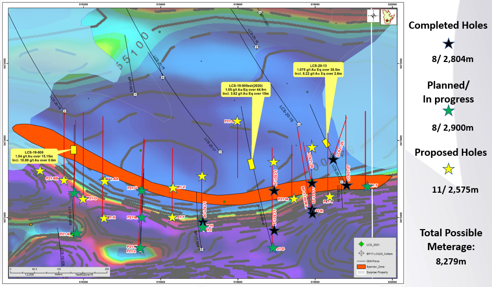
Figure 2: Location of Target 3, the Fox Showing and the Confluence area.
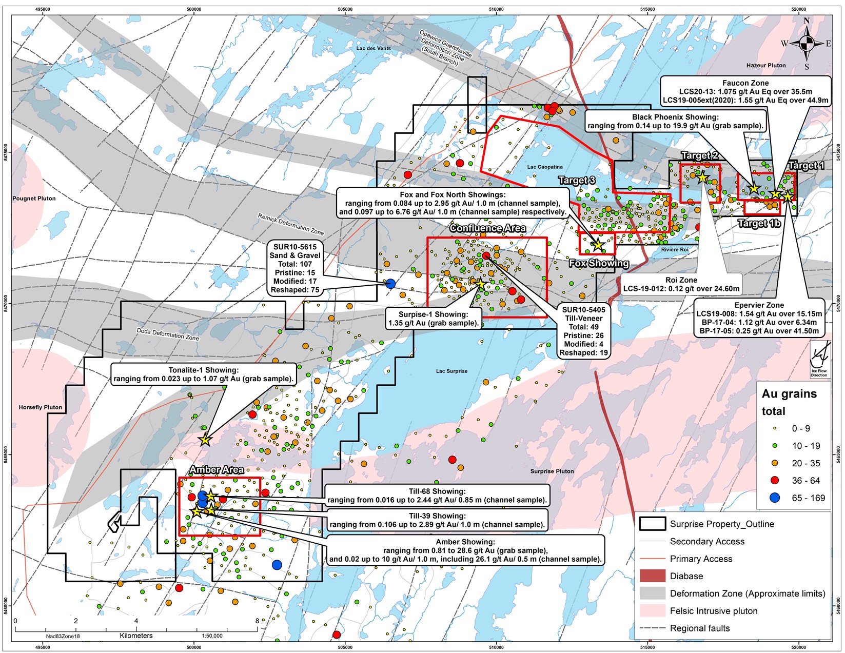
Figure 3: Target Area 3, surface expression. Note the three deep blue areas representing the large areas of potential alteration zones in addition to the large intrusive complex (potential heat source) and structural environment.
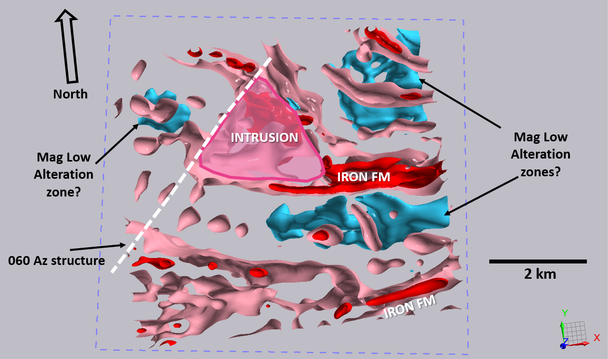
Figure 4: Geophysical signature and gold showings associated with the Fox Gold Showing.
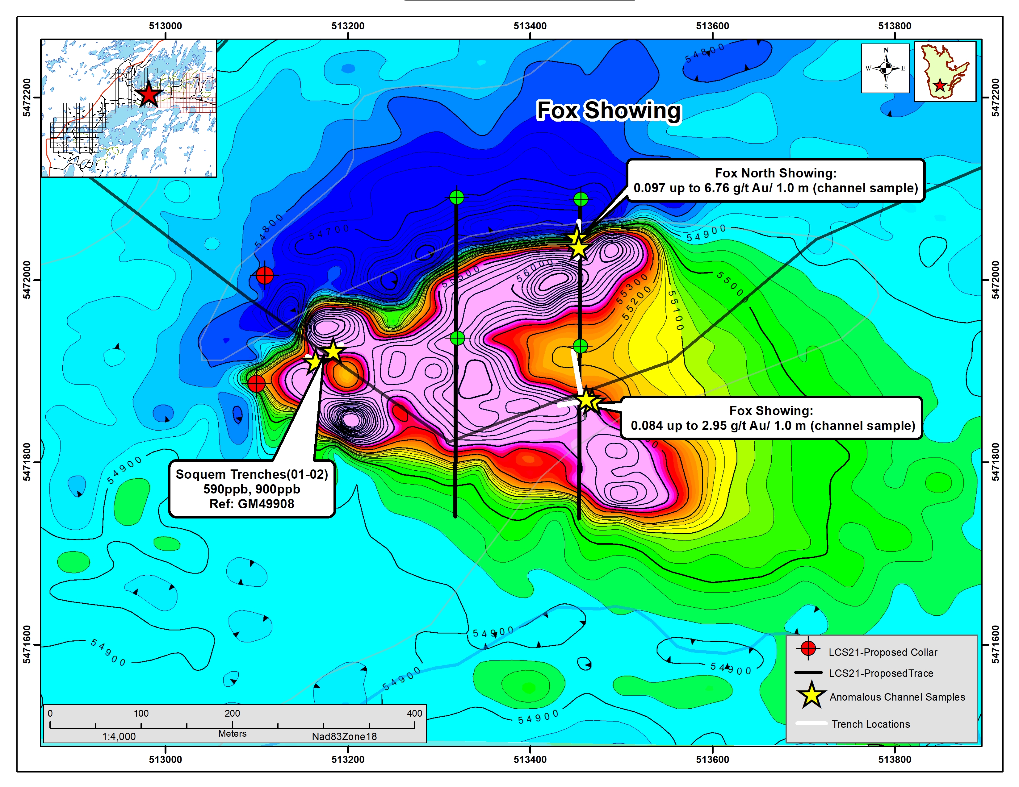
Figure 5. Three target areas to be tested associated with the Confluence Area, drill collars and traces. Each drill hole will be ~300m long.
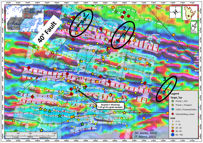
Figure 6. Areas covered by the ongoing Drone magnetic survey, total of 954km of flight lines at 50m spacing. Data will be the same high-quality data derived from the drone survey completed in 2019 used to help define the Falcon Gold Zone, target Area 1 and the geophysical properties associated with target Area 3. Same data will also refine targeting in the Confluence Area and the area to the south and south west.
SOURCE: Northern Superior Resources Inc.