Tuesday, 23 June 2020 07:01 AM
Company Update
TORONTO, ONTARIO / ACCESSWIRE / June 23, 2020 / Nighthawk Gold Corp. ("Nighthawk" or the "Company") (TSX:NHK)(OTCQX:MIMZF) is pleased to announce the results from the 2019 regional exploration program on its 100% owned Indin Lake Gold Property in the Northwest Territories, Canada. Field activities were carried out from June to early September 2019 and included detailed bedrock mapping and sampling of several key target areas (Figure 1).
A total of 1,485 grab and channel samples were collected to follow-up on some of the areas highlighted by the 2018 regional program (see press release dated February 19, 2019), and to continue exploring for new opportunities throughout the Indin Lake Gold Property. Field work has resulted in the discovery of new areas of mineralization and the expansion of several strategic gold occurrences. Regional diamond drilling in 2019 was limited to the Treasure Island Gold Project ("Treasure Island") where 19 holes were successfully completed, further advancing this well mineralized target area.
Dr. Michael Byron, President & CEO commented, "Nighthawk acquired Colomac and consolidated approximately 95% of the Indin Lake Greenstone Belt, including all of its historical gold mines, deposits, and showings to execute on the enormous untapped potential of this land package. Colomac is a unique brownfield asset with incredible promise that was largely overlooked until its affinity to one of the world's richest gold deposits was recognized by Nighthawk in 2012. As Colomac continues to progress and reveal its multi-million-ounce growth trajectory, the value of the fertile gold camp that it resides within also grows in prominence, and we control it all. The Indin Lake camp resembles many of Canada's prolific Archean gold camps except for its vastly unexplored state, and therein lies its value proposition; a juvenile gold camp with its full discovery potential yet to be realized."
Highlights
- Treasure Island 2019 Drill Program - All 19 holes intersected gold mineralization highlighted by hole T19-11 which intersected 12.70 m of 8.51 grams per tonne gold ("gpt" "Au"), including 7.30 m of 14.06 gpt Au. A 200-metre wide panel of mineralization has been traced continuously over 750 metres along strike from surface to upwards of 200 metres vertical depth where it remains open.
- High-grade gold at Andy Lake Project ("Andy Lake") - Channel and grab samples returned up to 42.80 gpt Au from mineralized shears.
- New high-grade gold mineralization at Barker-Vidie showing - Grab samples returned up to 13.65 gpt Au - high-grade zone extended to 300 m along strike.
- Zone 24 surface showing - Grab samples returned up to 8.83 gpt Au taken from surface quartz veins.
- New surface showings at Fishhook Gold Project ("Fishhook") - Grab samples returned up to 6.25 gpt Au from host silicate and oxide facies iron formation.
2019 Regional Exploration Results
The Indin Lake Greenstone Belt is home to several gold deposits and high-grade showings presenting a range of mineralization styles that are hosted in brittle regimes. These typomorphic features, being characteristic of most productive high-profile Archean gold camps, highlight the perspectivity of the Indin Lake Gold Camp and its capacity for major discoveries. Nighthawk's continued exploration success on its satellite targets supports the conviction that Colomac is not the only multi-million-ounce deposit in the camp. The many prominent regional targets provide a remarkable opportunity for growth and collectively strengthen the Company's 100% controlled regional play centered on Colomac. Many of these targets are at an early exploration stage and require additional work to unlock their ultimate potential, which the Company intends to follow up on in future regional programs.
Treasure Island
Treasure Island lies 11 km north of Colomac along the eastern end of the Treasure Island - Laurie Lake Mineralized Corridor, an underexplored 7 km long domain host to several high-priority gold showings (Figure 2). Mineralization consists of several en-echelon stacked zones spanning a regional east-west volcanic rock/sedimentary rock contact. Drilling to-date has outlined a 200-metre-wide and 750-metre-long assemblage of strongly altered rock that spans the southern shoreline of the island hosting the Main Zone and East Zone deposits.
In 2019 Nighthawk successfully completed its third drill campaign at Treasure Island to follow up on targets developed in both of its prior programs, where drilling confirmed and expanded on previous Nighthawk field reconnaissance programs (see press release dated February 4, 2020). Drilling explored the western and depth extensions of the Main Zone and the 300 metres of untested ground that lies between the two zones, resulting in the extension of the Main Zone up to 50 metres further west and infilling mineralization along strike between the zones (Table 1). All targets remain open along strike and to depth.
Given its extensive broad mineralized envelope with internal higher-grade domains, and with over 75 percent of the 7 km long mineralized corridor still unexplored, it represents exceptional untapped discovery potential. Treasure Island is considered a key satellite prospect proximal to Colomac and remains a focus of future exploration.
Table 1. Treasure Island 2019 Drilling Selected Results
|
Drill Hole |
Assay Results |
|
T19-01 |
6.25 m at 12.08 gpt Au |
|
Including |
2.50 m at 25.61 gpt Au |
|
T19-01B |
6.50 m at 10.20 gpt Au |
|
Including |
3.75 m at 16.38 gpt Au |
|
T19-11 |
12.70 m at 8.51 gpt Au |
|
Including |
7.30 m at 14.06 gpt Au |
|
T19-12 |
20.70 m at 2.57 gpt Au |
|
including |
8.20 m at 5.64 gpt Au |
Andy Lake
Andy Lake is located 20 km south of Colomac within the Gamey Lake Volcanic Panel; a NE-SW trending volcanic rock assemblage bordered by metasedimentary rocks to the east and west and intruded by the Andy Lake Granodiorite and associated granitoid dykes (Figure 1). In 2018 a 1:20,000 scale mapping program covering much of the panel led to the discovery of several new surface showings of high-grade gold mineralization up to 42.10 gpt Au hosted in multiple parallel north-trending shear zones within the granodiorite. Andy Lake is interpreted to be an orogenic style of gold mineralisation where gold-bearing quartz veins are hosted in the Andy Lake Granodiorite. The area is also anomalous in Silver (Ag), Bismuth (Bi), Molybdenum (Mo), Lead (Pb), and Copper (Cu).
The five sites that returned high-grade samples in the 2018 campaign were the focus of detailed follow-up exploration work in 2019 (Figure 3). Mechanical outcrop stripping and power washing was completed at four of the sites (A, B, C and E) over a 500 m N-S and 250 m E-W area where removal of all overburden material allowed for more expansive and detailed mapping (1:50 scale) and channel sampling. Local bedrock consists of strongly altered intrusive and volcanic rocks hosting a series of parallel N-S trending, steeply east-dipping, shears with associated mineralized quartz veins. Forty-three channels that ranged in length from 0.5 meters to 9.0 meters were cut into outcrops at the four sites totaling 147.75 metres. Of the 316 channel samples collected, 61 samples returned gold values greater than or equal to 0.54 gpt Au with the highest being 42.80 gpt Au. Sampling at all sites returned anomalous gold values suggesting that the region between and peripheral to the four sites is highly prospective (Figure 3).
The four mineralized shears described in the stripped areas, as well as several additional targets yet to be evaluated, form an echelon left-stepping fault array that developed in the host volcanic and intrusive rocks. Collectively, the shears define a highly prospective broader structural corridor, the Andy Lake mineralized corridor, that is approximately 500 meters N-S by 250 meters E-W and open in all directions.
The Andy Lake mineralized corridor is one of the Company's most prospective and undrilled gold targets within the Indin Lake Gold Camp. The presence of high-grade gold mineralization coupled with nested shear zones having an extensive areal footprint, defines another significant gold corridor within the Indin Lake Greenstone Belt that warrants further exploration.
Site A
Of the four areas, Site A returned the best gold values to-date (Figure 3). Ten channels were laid out over an outcrop area of 50 meters N-S by 20 meters E-W and spaced at 4-meter to 7-meter intervals with individual lengths ranging from 0.5 meters to 7.0 meters. All channels returned anomalous gold samples ranging from detection limit to 42.80 gpt Au (Table 2). Mineralization is open in all directions and to depth.
Table 2. Andy Lake Site A - 2019 select channel and grab sample results
|
Channel |
Sample |
Easting |
Northing |
Au (gpt) |
|
Grab |
A0563377 |
593044 |
7122854 |
42.80 |
|
A1 |
A0563685 |
593042 |
7122886 |
1.33 |
|
A2 |
A0563696 |
593044 |
7122882 |
1.18 |
|
A3b |
A0563644 |
593043 |
7122866 |
1.69 |
|
A5 |
A0563630 |
593045 |
7122853 |
1.77 |
|
A5 |
A0563633 |
593045 |
7122853 |
1.58 |
|
A6b |
A0563670 |
593046 |
7122882 |
1.40 |
|
A6b |
A0563669 |
593046 |
7122882 |
1.20 |
|
A6c |
A0563673 |
593047 |
7122875 |
2.78 |
|
A6c |
A0563672 |
593047 |
7122875 |
1.37 |
|
A7 |
A0563647 |
593048 |
7122872 |
2.80 |
|
A7 |
A0563651 |
593048 |
7122872 |
2.35 |
|
A7 |
A0563654 |
593050 |
7122872 |
2.27 |
|
A7 |
A0563650 |
593048 |
7122872 |
1.74 |
|
A7 |
A0563652 |
593048 |
7122872 |
1.13 |
|
A8 |
A0563634 |
593042 |
7122862 |
2.45 |
|
A8 |
A0563636 |
593042 |
7122862 |
1.51 |
|
A9a |
A0563619 |
593034 |
7122852 |
1.17 |
|
A9b |
A0563622 |
593039 |
7122852 |
2.68 |
Sites B, C, E
Seven channels ranging in length from 0.5 meters to 7.0 meters, and spaced less than 2.0 meters apart, were cut over 100 m2 at Site B. All channels returned anomalous samples but nothing above 0.25 gpt Au was noted. Eight channels were completed at Site C ranging in length from 0.5 meters to 8.0 meters to sample an outcrop area of 360 m2. Channels were cut into all lithologies to sample across shear veins and tension gashes. A total of 58 channel samples were collected that returned assays up to 2.74 gpt Au. At site E, 18 channels ranging in length from 0.5 meters to 7.0 meters were completed and 108 channel samples were collected returning assays up to 5.06 gpt Au (Table 3).
Table 3. Andy Lake Sites C and E - 2019 select channel sample results
|
Channel |
Sample |
Easting |
Northing |
Au (gpt) |
|
C1 |
A0563763 |
592948 |
7122544 |
0.47 |
|
C1 |
A0563758 |
592952 |
7122549 |
0.38 |
|
C5 |
A0563781 |
592949 |
7122536 |
1.18 |
|
C7 |
A0563791 |
592964 |
7122532 |
2.74 |
|
C7 |
A0563790 |
592964 |
7122532 |
1.04 |
|
C7 |
A0563789 |
592964 |
7122532 |
0.60 |
|
C7 |
A0563796 |
592964 |
7122532 |
0.42 |
|
E5a |
A0563539 |
592983 |
7122707 |
0.71 |
|
E14 |
A0563559 |
592971 |
7122689 |
5.06 |
|
E16 |
A0563568 |
592949 |
7122688 |
1.52 |
|
E16 |
A0563569 |
592949 |
7122688 |
0.42 |
|
E17 |
A0563572 |
592950 |
7122686 |
2.37 |
|
E18 |
A0563573 |
592948 |
7122684 |
1.36 |
Barker-Vidie - High-grade gold showing
Barker-Vidie is located 27 km south-southwest of Colomac within a N-S trending volcanic rock assemblage. The showing is underlain by strongly carbonate altered intermediate to mafic volcanic rocks (Figure 1 & 4). In 2019 prospecting at Barker-Vidie was directed to follow-up on a 23.60 gpt Au grab sample collected in 2018. A total of 53 grab samples were taken along the E-W and N-S trending portion of the Indin Lake shoreline returning assays up 13.65 gpt Au (Table 4). Work in 2019 has increased the strike length of the high-grade showing to 300-meters highlighting the untapped potential of this showing.
Table 4. Barker-Vidie - 2019 select grab sample results
|
Sample |
Easting |
Northing |
Au (gpt) |
|
A0563343 |
586278 |
7115895 |
13.65 |
|
A0562724 |
586369 |
7115684 |
12.10 |
|
A0562726 |
586238 |
7115952 |
5.36 |
Zone 24 surface gold showing - Part of the Colomac Gold Project ("Colomac")
The Zone 24 and nearby Zone 27 deposits are near-surface gold deposits located 4.5 km northeast of Colomac (Figure 5) that are included in Nighthawk's 2018 Colomac Gold Project mineral resource estimate (see press release dated June 13, 2018). Although never drilled by the Company, surface work at Zone 24 in 2019 focused on developing a better understanding of the controls on mineralization which is needed to help direct future drilling to expand on this promising deposit.
The two deposits lie along a north-trending high-strain zone that follows a felsic to intermediate volcanic rock and metasedimentary rock contact with a gabbroic intrusion sandwiched between them (Figure 5). Zone 24 outcrops exhibit intense rusty brown iron oxide surface weathering with milky white to smoky grey quartz flooding and semi-massive sulfide patches common within the southern portion of the showing. Fieldwork in 2019 extended the area of interest towards the north highlighted by an 8.38 gpt Au grab sample. Zone 24 and Zone 27 have received limited exploration attention yet remain a high priority exploration target for resource expansion as does the area between the two deposits and along strike.
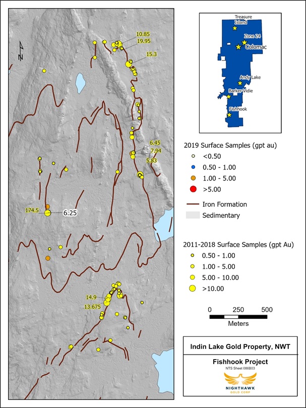
Fishhook- New high-grade samples
Fishhook is located 40 km south of Colomac and is the southern most project within Nighthawk's Indin Lake Gold Property (Figure 1 & 6). Gold showings are hosted in a series of complex folded amphibolitic oxide-silicate iron formations that span several kilometres. Detailed outcrop sampling in 2018 returned several high-grade results up to 174.50 gpt Au (Figure 6). In 2019 field activities were limited to expanding on some of these results, including sampling areas lateral to the 2018 high-grade sample, which returned grab samples up to 6.25 gpt Au over an 86-meter strike length (Table 5).
Fishhook bears a strong resemblance to the Company's Damoti Lake Gold Deposit, a high-grade gold deposit located northeast of Fishhook. Fishhook has received little exploration attention from Nighthawk to-date, however, its high-grade nature, structural style, host lithology and extensive mineralized footprint are comparable to the many iron formation hosted gold deposits in other Archean greenstone belts, thus solidifying its position as one of the Company's top prospects.
Table 5. Fishhook - 2019 select grab sample results
|
Sample |
Easting |
Northing |
Au (gpt) |
|
A0562715 |
587122 |
7104955 |
6.25 |
|
A0562100 |
587122 |
7104959 |
1.83 |
|
A0562309 |
587119 |
7105009 |
1.63 |
|
A0562311 |
587119 |
7105009 |
1.21 |
|
A0562712 |
587122 |
7104955 |
0.85 |
|
A0562315 |
587117 |
7105041 |
0.36 |
|
A0562310 |
587119 |
7105009 |
0.36 |
Regional Mapping: Albatross gold trend, Nice Lake sill, Santa Zone and Laurie Lake showings
The Albatross gold trend lies 15 km southwest of the Colomac deposit (Figure 1), within a couple of hundred metres from a decommissioned all-season haulage road that links the Cass and Kim gold deposits with the past-producing Colomac mine. Previous samples of up to 10.30 gpt Au were collected from gold showings associated with brittle-ductile high strain zones that separate units of meta-volcanic and intrusive rocks from meta-sedimentary rocks. Intrusion-hosted and volcanic-hosted showings are recognized in association with the brittle-ductile high strain zones.
The 2019 field program helped advance the Albatross gold trend as several anomalous grab samples were collected that assayed up to 3.34 gpt Au. Nighthawk is encouraged with the results to-date and believes that the area has the potential to host similar opportunities as the nearby Cass gold deposit.
Grid sampling was conducted along the Nice Lake sill (Figure 1) located 2 km southeast of Colomac. The sill was discovered in 2016 and has since been the focus of expanded field activities, highlighted by 2018 grab samples that returned 41.90 gpt Au, 38.90 gpt Au, and 19.05 gpt Au. Nice Lake and the recently discovered Santa Zone prospect located along strike and north of Nice Lake, are underlain by an intercalated sequence of massive and pillowed basalt-andesite flows, concordant gabbroic sills, felsic flows, pyroclastic and epiclastic rocks. Two different types of syn-volcanic sills are present, high-level feldspar+quartz porphyries and those of gabbro-diorite composition. Sub vertical north-trending shears parallel the volcanic stratigraphy. The structural setting of the Nice Lake corridor with north-trending strain zones and brittle syn-volcanic intrusions is comparable to the structural setting of the Colomac Main Sill. Consequently, the Nice Lake corridor, which extends 4-5 kilometres to the south, remains a key exploration target for the Company.
The Laurie Lake showings are located 8.5 km northwest of Colomac along the western extent of the Treasure Island-Laurie Lake Mineralized Corridor (Figure 1). Regional geology consists of alternating units of mafic meta-volcanic rocks and turbiditic meta-sediments. In 2019, detailed geological mapping covered a 2.34 km area where high-grade gold grab samples were taken from quartz veins in 2018. This latest program was successful in identifying several new priority targets for future investigations.
Two historical gold showings south of Colomac, MAR A-Zone and LOM 2633-6, were also investigated in 2019 (Figure 1). Work in both areas has validated historical reports of mineralization as grab samples up to 1.16 gpt Au were collected from outcrop exposures proximal to the showings and have identified new targets worthy of further work.
Figure 1. Indin Lake Gold Property - 2019 Regional Bedrock Sampling
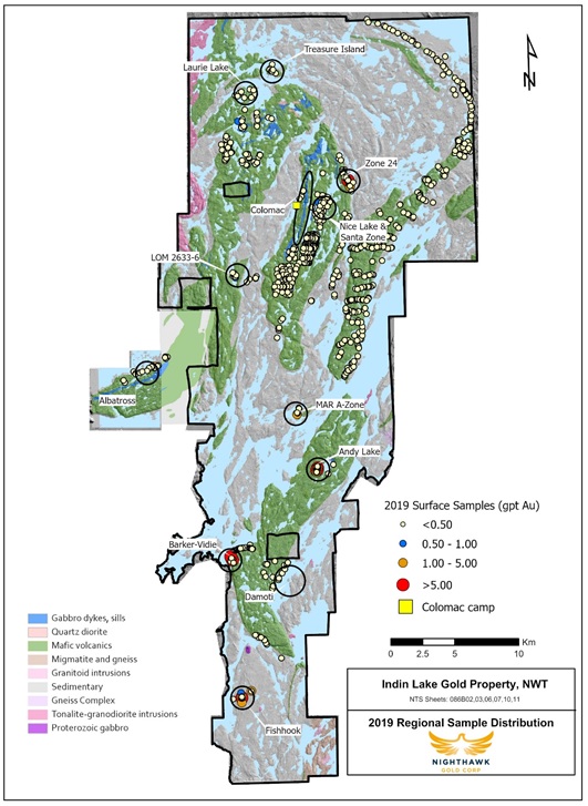
Figure 2. Treasure Island - 2019 Drillhole Locations
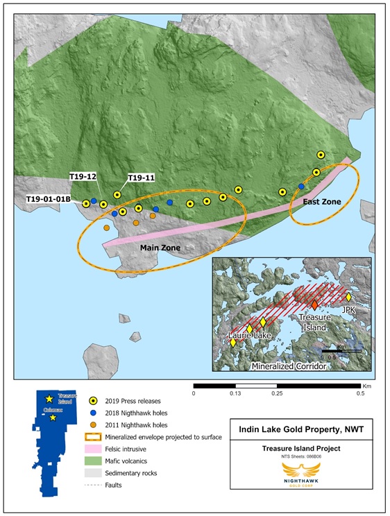
Figure 3. 2019 Andy Lake Channel Samples and Mapped Sites (red polygons).
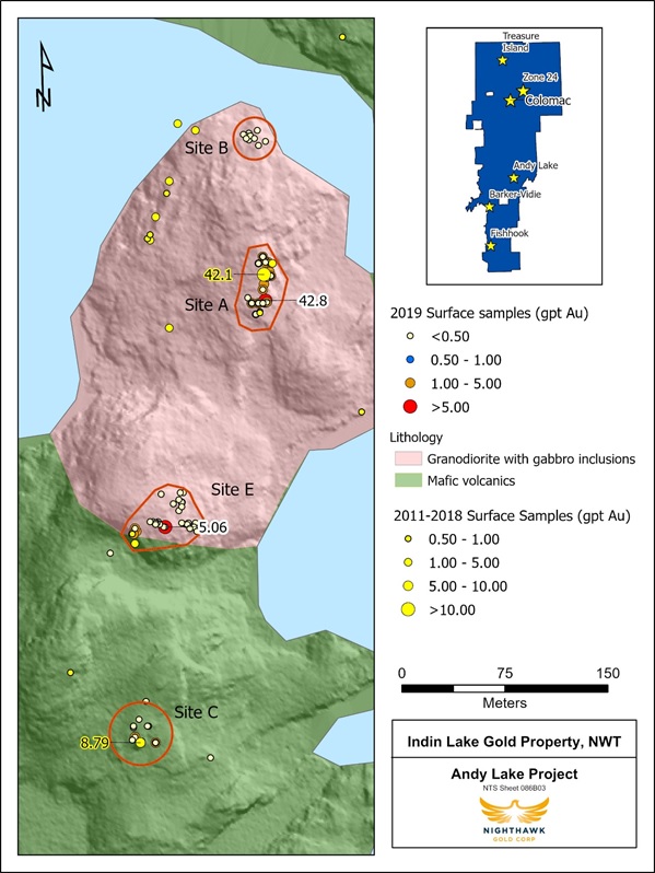
Figure 4. Barker-Vidie Surface Sample Location Map.
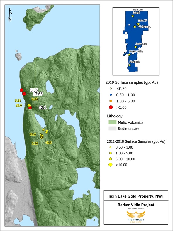
Figure 5. Zone 24 Surface Sample Location Map.
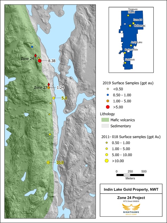
Figure 6. Fishhook Surface Sample Location Map.
Technical Information
Nighthawk has implemented a quality-control program to comply with best practices in the sampling and analysis of drill core. Drill core samples were transported in security-sealed bags for analyses at ALS Global Assay Laboratory in Vancouver, BC ("ALS Global"). ALS Global is an ISO/IEC 17025 accredited laboratory. Pulp and metallics assaying for gold was conducted on the entire pulverized sample.
As part of its QA/QC program, Nighthawk inserts external gold standards (low to high-grade) and blanks every 20 samples in addition to the standards, blanks, and pulp duplicates inserted by ALS Global.
About Nighthawk
Nighthawk is a Canadian-based gold exploration company with 100% ownership of a district-scale land position within the Indin Lake Greenstone Belt, located approximately 200 km north of Yellowknife, Northwest Territories, Canada. Nighthawk is focused on advancing the Colomac Gold Project with a current inferred resource of 2.6 million ounces of gold (50.3 million tonnes at an average grade of 1.62 grams per tonne gold), as well as advancing its other regional gold deposits and showings within this largely underexplored Archean gold camp.
The Company has an experienced and dedicated team and is well funded to complete its goals and objectives over the next 12 months.
Qualified Person
Dr. Michael J. Byron, Ph.D., P.Geo., President & Chief Executive Officer of Nighthawk, who is the "Qualified Person" as defined by NI 43-101 for this project, has reviewed and approved of the technical disclosure contained in this news release. Please refer to NI 43-101 technical report "Technical Report and mineral resource estimate update on the Colomac Property of the Indin Lake Project", dated June 13, 2018, as filed under the company's profile on www.sedar.com.
FOR FURTHER INFORMATION PLEASE CONTACT:
NIGHTHAWK GOLD CORP.
Tel: 1-647-794-4313
Email: [email protected]
Website: www.nighthawkgold.com
Dr. Michael Byron
President & CEO
Tel: 1-647-794-4359
Michael Leskovec
CFO
Tel: 1-647-794-4360
Suzette N Ramcharan
VP, Corporate Development
Tel: 1-647-794-4362
Neither the Toronto Stock Exchange has neither reviewed nor accepts responsibility for the adequacy or accuracy of this news release.
Forward-Looking Information
This news release contains "forward-looking information" within the meaning of applicable Canadian securities legislation. Forward-looking information includes, but is not limited to, information with respect to the Company's continued exploration programs (including size and budget) and the ability to advance targets; the ability to grow ounces at Colomac, the ability to raise the necessary capital on acceptable terms in order to conduct exploration programs including mapping, prospecting and drilling activities and identify new targets in future years, as well as any intention to expand these programs in the future. Generally, forward-looking information can be identified by the use of forward-looking terminology such as "plans", "expects", or "does not expect", "is expected", "budget", "scheduled", "estimates", "forecasts", "intends", "anticipates", or "does not anticipate", or "believes" or variations of such words and phrases or state that certain actions, events or results "may", "could", "would", "might", or "will be taken", "occur", or "be achieved".
Forward-looking information is based on the opinions and estimates of management at the date the information is made, and is based on a number of assumptions and is subject to known and unknown risks, uncertainties and other factors that may cause the actual results, level of activity, performance or achievements of Nighthawk to be materially different from those expressed or implied by such forward-looking information, including risks associated with the exploration, development and mining such as economic factors as they effect exploration, future commodity prices, changes in foreign exchange and interest rates, actual results of current exploration activities, government regulation, political or economic developments, environmental risks, permitting timelines, capital expenditures, operating or technical difficulties in connection with development activities, employee relations, the speculative nature of gold exploration and development, including the risks of diminishing quantities of grades of reserves, contests over title to properties, and changes in project parameters as plans continue to be refined as well as those risk factors discussed in Nighthawk's annual information form for the year ended December 31, 2017, available on www.sedar.com. Although Nighthawk has attempted to identify important factors that could cause actual results to differ materially from those contained in forward-looking information, there may be other factors that cause results not to be as anticipated, estimated or intended. There can be no assurance that such information will prove to be accurate, as actual results and future events could differ materially from those anticipated in such information. Accordingly, readers should not place undue reliance on forward-looking information. Nighthawk does not undertake to update any forward-looking information, except in accordance with applicable securities laws.
SOURCE: Nighthawk Gold Corp