


NOT FOR DISTRIBUTION TO US NEWSWIRE SERVICES NOR FOR DISSEMINATION IN THE UNITED STATES OF AMERICA
DIDCOT, UK / ACCESSWIRE / October 2, 2018 / Altus Strategies Plc (AIM: ALS & TSX-V: ALTS), the Africa focused exploration project generator, announces that it has defined drill targets to test a potential karst-style gold deposit at its 100% owned 24km2 Lakanfla gold project ("Lakanfla" or the "Project") in Western Mali. Lakanfla is strategically located 6.5km from the multi-million ounce Sadiola gold mine, in the world renowned 'Kenieba Window' gold belt.
Highlights:
- Drill targets established to define a potential karst-style gold deposit
- Previous high grade drill intersections of 9.78g/t Au over 12m & 5.20g/t Au over 16m
- Intensive artisanal gold workings along more than 2.5km of strike length
- Project located in world renowned gold producing belt and 6.5km from Sadiola mine
- Targets based on reinterpretation of historic geochemical, lithological and geophysical data
Steven Poulton, Chief Executive of Altus, commented:
"The Lakanfla gold project is reported to have historically hosted between 4,000 and 10,000 artisanal gold miners, targeting mineralised breccias from surface. Drilling of these breccias by previous operators has returned a number of high grade intersections, including 9.78g/t Au over 12m from 12m and 5.20g/t Au over 16m from 36m. Following extensive reinterpretation of historic project data, a series of priority drill targets have been established to potentially define a 'karst style' deposit that may be present at depth.
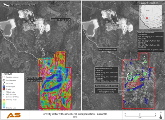
"The drill targets are centred on a large geophysical gravity low, which is up to 4km long and 0.5km wide. This anomaly is hosted within carbonate lithologies surrounding a granodiorite intrusive. A karst deposit, if present, might be analogous to the nearby FE3 & FE4 open pits, which form part of the multi-million ounce Sadiola gold mine located 6.5km northwest of Lakanfla, as well as the former multi-million ounce Yatela gold mine located 35km to the northwest. We have prepared a technical presentation on the Lakanfla gold project and made this available on our website."
An updated technical presentation on the Lakanfla project can be downloaded from the following link: http://altus-strategies.com/site/assets/files/4252/altus_lakanfla_project_review.pdf
The following figures have been prepared and relate to the disclosures in this announcement and are visible in the version of this announcement on the Company's website (www.altus-strategies.com) or in PDF format by following this link: http://altus-strategies.com/site/assets/files/4449/altus_nr_-_lakanfla-_02_oct_2018.pdf
- Location of the Lakanfla licence in western Mali is shown in Figure 1.
- Lakanfla gravity geophysical anomaly & geology is shown in Figure 2.
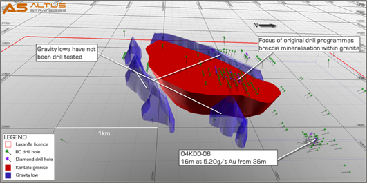
- A schematic 3D model of drill targets at Lakanfla is shown in Figure 3.
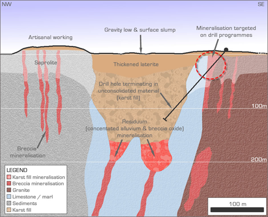
- A conceptual model of the Lakanfla karst targets is shown in Figure 4.
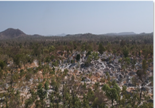
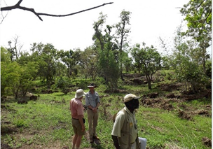
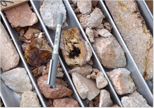
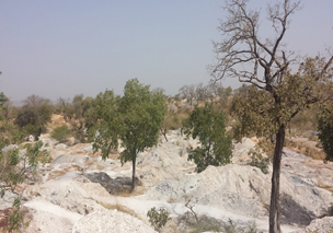
- A selection of Lakanfla photos is shown in Figure 5.
Figure 1. The location of Lakanfla in Western Mali

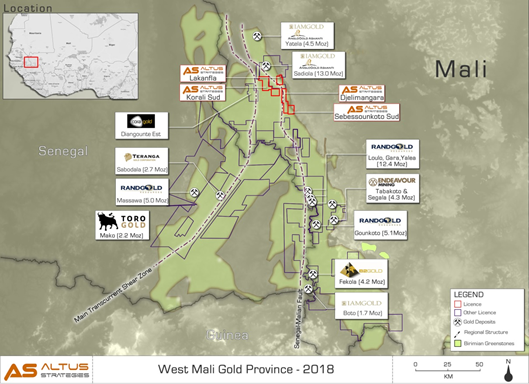
Figure 2. Lakanfla gravity geophysical anomaly & geology


|
|
 |
|
Ground collapse coincident with gravity anomaly |
Drone view of Lakanfla workings |
|
|
|
|
Breccia from historic drilling at Lakanfla |
Artisanal workings |


Lakanfla Project: Location
The 24km2 Lakanfla project is located 5km east of the Company's Diba (Korali Sud) oxide gold project and approximately 6.5km southeast of the karst-type FE3 and FE4 open pits of the multi-million ounce Sadiola gold mine and 35km southeast of the former multi-million ounce Yatela karst-type mine. Lakanfla is bounded by the Sadiola permit area on its north, west and southern boundaries. Sadiola and Yatela are both part owned by Anglogold Ashanti (JSE: ANG, NYSE: AU and ASX: AGG) and IAMGOLD Corporation (TSX: IMG & NYSE: IAG).
Lakanfla Project: Karst Geology
Karst style deposits are known to form from the dissolution and collapse of carbonate (limestone) rocks. The weathering of these rocks, if mineralised with low grade gold and sulphides, can results in the precipitation of a higher grade 'supergene' and potentially economic gold mineralised residuum, above a more resistant basal layer. The dissolution of the limestones often means such deposits are associated with geophysical gravity lows, resulting from the formation of voids at depth. They may also contain sands and other more recent geological materials occurring unconformably in the geological sequence. These materials will have either been blown or fallen into the depression created during the karstification (dissolution) process.
Lakanfla Project: Karst Targets
At Lakanfla a consistent series of gravity lows exist. These are up to 0.5km wide, with a total strike length of approximately 4km. The gravity lows are hosted within limestone lithologies surrounding a granodiorite intrusion and its associated hydrothermal aureole. Surface sagging features, considered to be a result of the formation of dissolution voids at depth, have been mapped as being more than 100m long in places and are often coincident with the gravity lows. A number of the gravity lows are adjacent to N-S trending artisanal gold workings and are also coincident with apparent gradient array IP resistivity lows. Interpretation of the residual IP anomalies has defined a series of intersecting regional and local scale structures which are considered to have potentially promoted the karst formation process. The gravity lows and lithological trends may indicate areas of deep weathering of altered calcareous sediments, dissolution collapse and potential supergene gold deposition. None of these priority targets have been systematically drill tested to date.
Of the historic drilling that has been undertaken at Lakanfla, thirty five holes coincide with the priority targets. However, the majority of holes drilled were no deeper than 75m vertical depth and only one was drilled deep enough to test the karst potential, attaining a vertical depth of 161m. Critically drill hole 04KDD-08, which was located on the margin of a gravity low reached the target depth and terminated in loosely consolidated sand (from 165m to 171m). As such hole 04KDD-08 provides strong evidence for the presence of a potential karst-type system.
Lakanfla Project: Exploration History
Historic exploration at Lakanfla has included soil sampling across the entire licence area, on a 500m x 250m (and in places 250m x 100m) sample grid. The programme defined a number of anomalies which were further refined by shallow auger drilling. Follow up diamond, RC and RAB drilling programmes primarily targeted shallow gold mineralised breccias. These breccias are also the primary target for artisanal gold miners, the workings of which extend for approximately 2.5km of strike length. The majority of the drilling at Lakanfla was completed between 2001 and 2011. A number of selected historic intersections are highlighted in Table 1.
Table 1: Lakanfla selected historic shallow drill intersections
|
Hole ID |
From (m) |
To (m) |
Intersection (m) |
Grade (g/t Au) |
|
01KRAB-03 |
12.00 |
24.00 |
12.00 |
9.78 |
|
03KRC-19 |
52.00 |
90.00 |
38.00 |
1.19 |
|
04KDD-06 |
36.00 |
52.00 |
16.00 |
5.20 |
A number of geophysical programmes have been completed at Lakanfla, including ground based induced polarisation, high resolution resistivity, magnetic and gravity surveys as well as airborne VTEM and gravity surveys. Significantly the completion of the ground gravity survey, which generated the Karst targets on the margins of the granodiorite intrusion, post-dates all of the drilling completed at Lakanfla.
Qualified Person
The technical disclosure in this regulatory announcement has been read and approved by Steven Poulton, Chief Executive of Altus. A graduate of the University of Southampton in Geology (Hons), he also holds a Master's degree from the Camborne School of Mines (Exeter University) in Mining Geology. He is a Fellow of the Institute of Materials, Minerals and Mining and has over 19 years of experience in mineral exploration and is a Qualified Person under the AIM rules and National Instrument 43-101 under the rules of the TSX.
Market Abuse Regulation (MAR) Disclosure
Certain information contained in this announcement would have been deemed inside information for the purposes of Article 7 of Regulation (EU) No 596/2014 until the release of this announcement.
For further information you are invited to visit the Company's website www.altus-strategies.com or contact:
|
Altus Strategies Plc Steven Poulton, Chief Executive
|
Tel: +44 (0) 1235 511 767 |
|
SP Angel (Nominated Adviser) Richard Morrison / Soltan Tagiev
|
Tel: +44 (0) 20 3470 0470 |
|
SP Angel (Broker) Richard Parlons / Jonathan Williams
|
Tel: +44 (0) 20 3470 0471 |
|
Blytheweigh (Financial PR) Tim Blythe / Camilla Horsfall / James Husband |
Tel: +44 (0) 20 7138 3204 |
About Altus Strategies Plc
Altus is a London (AIM: ALS) and Toronto (TSX-V: ALTS) listed, diversified and Africa focused mineral exploration project generator. Through our subsidiaries we discover new projects and attract third party capital to fund their growth, development and ultimately exit optionality. This strategy enables Altus to remain focused on the acquisition of new opportunities to be fed into the project generation cycle and aims to minimise shareholder dilution. Our business model is designed to create a growing portfolio of well managed and high growth potential projects and royalties, diversified by commodity and by country. Altus currently has eighteen projects in six commodities across six countries. We aim to position our shareholders at the vanguard of value creation, but with significantly reduced risks traditionally associated with investments in the mineral exploration sector.
Cautionary Note Regarding Forward-Looking Statements
Certain statements in this news release contain forward-looking information. These statements address future events and conditions and, as such, involve known and unknown risks, uncertainties and other factors which may cause the actual results, performance or achievements to be materially different from any future results, performance or achievements expressed or implied by the statements. Such factors include without limitation the completion of planned expenditures, the ability to complete exploration programs on schedule and the success of exploration programs. Readers are cautioned not to place undue reliance on the forward-looking information, which speak only as of the date of this news release.
Neither the TSX Venture Exchange nor its Regulation Services Provider (as that term is defined in the policies of the TSX Venture Exchange) accepts responsibility for the adequacy or accuracy of this release.
Glossary of Terms
The following is a glossary of technical terms:
"Artisanal" means local people conducting mining, often with rudimentary equipment
"Au" means gold
"g/t" means grams per tonne
"Grade(s)" means the quantity of ore or metal in a specified quantity of rock
Karst style deposits are known to form from the dissolution and collapse of carbonate (limestone) rocks. The weathering of these rocks, if mineralised with low grade gold and sulphides, can results in the precipitation of a higher grade ‘supergene’ and potentially economic gold mineralised residuum.
"m" means metres
SOURCE: Altus Strategies Plc