


TORONTO, ONTARIO / ACCESSWIRE / September 10, 2019 / Rupert Resources Ltd (TSX-V:RUP)(“Rupert” or “the Company”) provides an update on exploration activities at the Pahtavaara Project, Northern Finland. The Pahtavaara Project comprises a contiguous regional land package of 297km2 and a permitted 1,400tpd mill (the “Pahtavaara Project”).
Highlights
- Follow-up drilling at Area 1 discoveries demonstrates further mineralisation
- Regional drilling program of up to 15,000m has commenced on licence wide targets
- Detailed ground gravity survey completed over 200km2 of the licence holding
- Updated regional geological interpretation highlights new prospective targets
- Pahtavaara Mine infill, extension and near mine drilling to restart in October
James Withall, CEO of Rupert Resources commented “Our understanding of the regional geological setting continues to grow and we are well financed to move the Pahtavaara Project forwards. Over the coming nine months our fieldwork, base of till sampling and diamond drilling programs will test our highest priority licence wide targets. Initial regional drilling will follow-up the discoveries at Area 1, announced in May. Furthermore, in October a drilling program will commence at the Pahtavaara mine to increase resource confidence and further test for mineralised extensions.”
Area 1 Follow-up Drilling
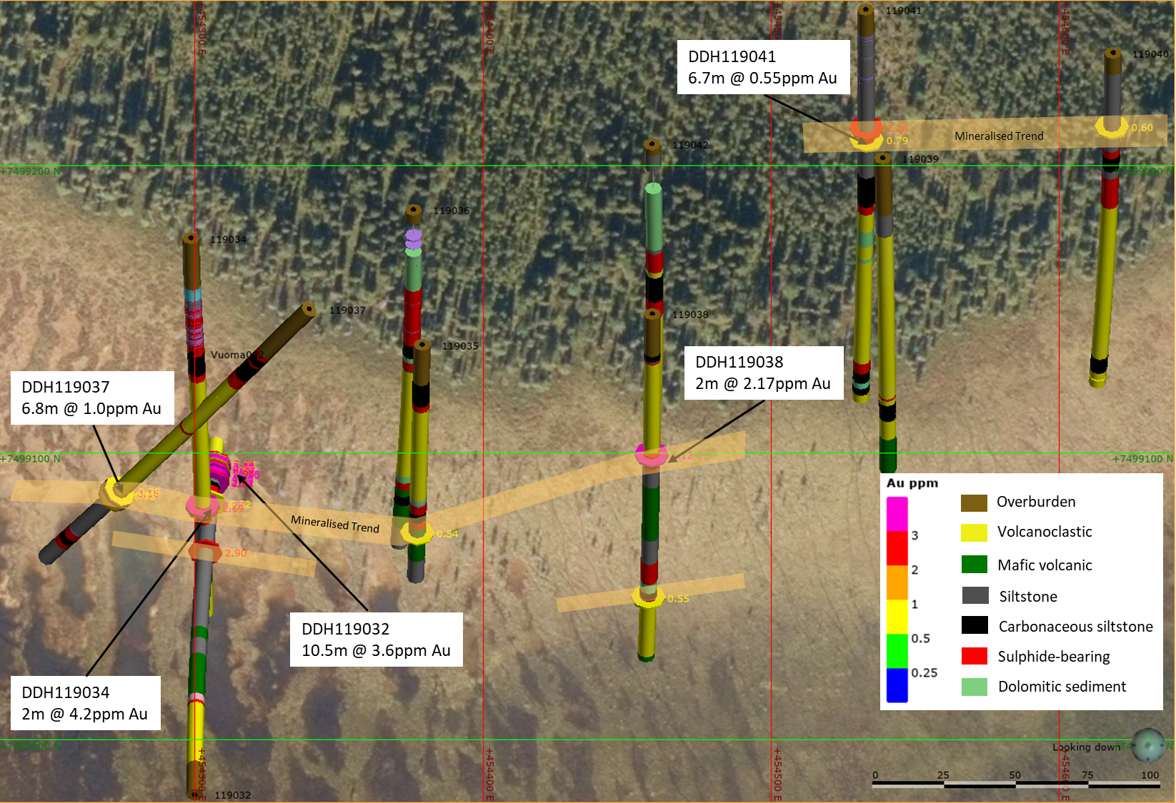
The systematic exploration program Rupert is undertaking was validated in May 2019 with the discovery of gold mineralisation at Area 1 in a four-hole reconnaissance program totalling 525m. Significant intercepts included 10.5m grading 3.55g/t Au in hole 119032, 90m below a base of till anomaly of 21g/t Au at the northern most target (“Vuoma North”). A follow up program of eight wide-spaced holes totalling 1440m was undertaken to test for strike extent along a coincident linear magnetic anomaly. All eight holes drilled returned anomalous gold, with significant intercepts of 2m @ 4.23g/t Au, 30m from above the reported DDH119032 intercept, and three additional >1g/t intersections along strike including DDH119037 with 4m grading 1.51g/t Au from 130m. See appendix figure 1 and tables 1 and 2 for hole location and assay data.
The drilling at Vuoma North confirmed a steeply dipping sedimentary and intermediate-mafic volcanic stratigraphy, characteristic of an extensional basin setting. Gold is associated with pyrite that is focused at zones of structural deformation related to lithological boundaries. The drilling extended the mineralised zone originally drilled in hole 119032 and identified further gold mineralisation associated with separate lithological boundaries over 200m to the north east. Further follow-up drilling is planned at this target in the coming months.
Regional Drilling Program Underway
Exploration drilling has now recommenced in selected areas and will sequentially test our highest priority regional targets, with up to 15,000m of diamond drilling over the coming six months.
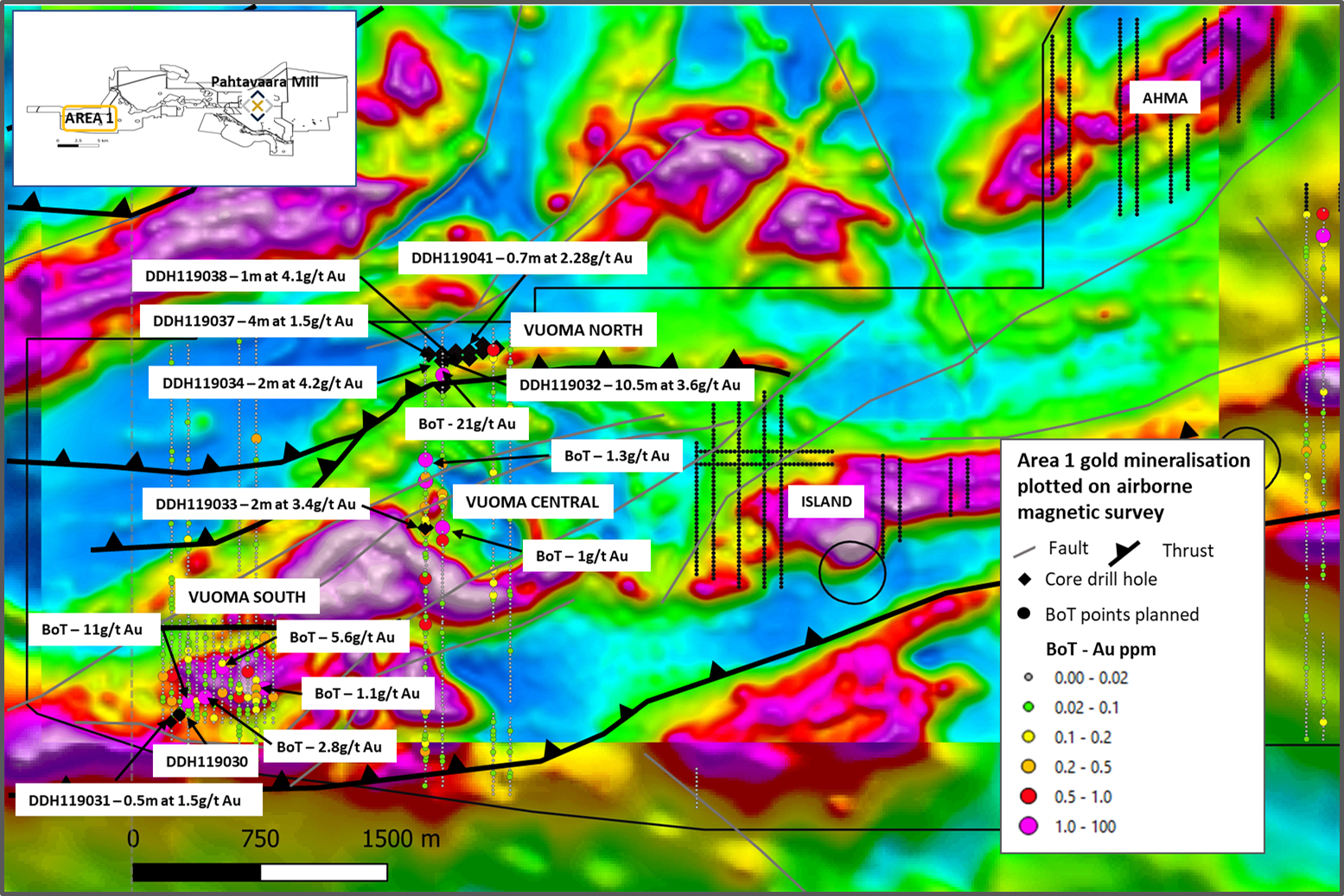
Work is already underway at a second target in the centre of Area 1, (“Vuoma Central”). The discovery hole 119033 at Vuoma Central intersected 2.0m grading 3.4g/t Au along with broad zones of lower grade gold and copper mineralisation associated with sulphides throughout the length of the hole (see release May 21, 2019). The drilling is targeting the same discrete magnetic anomaly and broad coincident anomalous gold and base metals in base of till samples. Importantly, new multi-element data for the hole indicates a robust association between pyrrhotite and Au, along with Ni-Co-Cu+/-Ag-Te, particularly evident in lower part of the hole where Au grade intervals are broader and more consistent. Re-evaluation of geophysical data in this area has demonstrated similar targets that will initially be tested by base of till sampling. See appendix figure 2.
Updated Regional Geological Interpretation
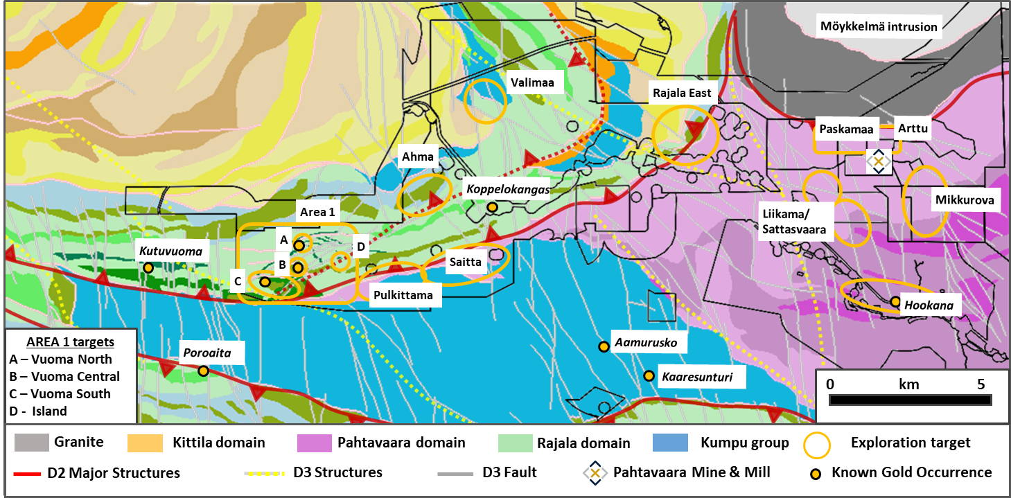
In mid 2018 the company announced its first re-appraisal of the regional geological setting of the Pahtavaara project and prospectivity for hosting further orogenic gold deposits beyond the Pahtavaara mine (see release July 30, 2018). Over the past 12 months our understanding has taken a further significant step forward. A detailed ground gravity survey over 200km2 of the licence, detailed mapping, logging of historic drilling and importantly the recent drilling in the south western extents at “Area 1” have all contributed. See appendix figure 3.
Key conclusions:
- The definition of the main phase of gold mineralisation associated with the second D2 structural deformation phase during convergence and basin formation around an archean dome. A later D3 east-west compression phase potentially re-activates deep seated structures.
- Identification of distinct geological domains within Savaukoski Group i.e. Pahtavaara Domain ultramafics in the east forming two distinct volcanic centres and, the Rajala Domain mafic-intermediate volcanics, coarse sediments and fine turbidites in the west that demonstrate more similarites to the Kittila group to the north west.
- The 25km structural corridor that acts as a boundary between the domains, likely acted as a regional fluid conduit, and has potential to host mineralisation, as demonstrated by the previous discoveries in Area 1 and gold occurrences at Koppelokangas and Kutuvuoma.
Pahtavaara Mine Exploration
In October an infill and extension drill program will commence at the Pahtavaara mine to improve the confidence of the current Inferred resource of 474kozs at 3.2g/t Au and followup potential extensions to mineralisation previously announced (see release April 9, 2019). Up to 7,000m is planned to target near-surface mineralisation using surface RC and diamond drilling and depth extensions, that will be drilled from the current underground infrastructure. The mine historically produced 350kozs of gold from both open pits and underground. Key focus areas are multiple Harpoon zones and the newly-discovered NFE in the east, the T-Zone to the south, the Karoliina zone to the west and extensions to the historically mined Samurai zone.
Following completion of the program the Company plans to deliver a new NI 43-101 Mineral Resource Estimate in mid 2020.
Near Mine Drilling
Further drilling is also planned at a number of near mine targets identified through BoT sampling and re-evaluation of geophysical data. This will follow-up on 18 holes (total 1,604m) that were drilled in February 2019 to test a cohesive BoT anomaly (of up to 1.3g/t Au), 800m to the north west of the Pahtavaara Mine at Paskamaa East and a further BoT anomaly that trends to the north east towards the more recently identified Arttu target. A series of shallow drill traverses were completed that intersected ultramafic rock types and amphibole alteration of a similar style to that associated with mineralisation at Pahtavaara mine, with a best intercept of 2.4g/t Au over 1.4m from 11.6m in hole 119020. Evidence of broader low-grade gold anomalism was demonstrated by intersections of 0.2g/t Au over 18m from 10m in hole 119021 and 0.2g/t over 7m from 9m in hole 119018, with the mineralisation located in shallowly dipping brittle fractures. The gold intersections were equivalent in grade and extent to the original base of till sampling results, and it is considered positive that the BoT appears to reflect the underlying mineralisation in this case. See appendix tables 3 and 4 for hole location and assay data.
Review by Qualified Person, Quality Control and Reports
In compliance with National Instrument 43-101, Mr. Mike Sutton, P.Geo. is the Qualified Person who supervised and approved the preparation of the scientific and technical disclosure in this news release.
Samples are prepared by ALS Finland in Sodankylä and assayed in ALS laboratory in Ireland, Romania or Sweden. All samples are under watch from the drill site to the storage facility. Samples are assayed using fire assay method with aqua regia digest and analysis by AAS for gold. Over limit analysis for >10 ppm Au is conducted using fire assay and gravimetric finish. For multi-element assays Ultra Trace Level Method by HF-HNO3-HClO4 acid digestion, HCl leach and a combination of ICP-MS and ICP-AES is used. The Company’s QA/QC program includes the regular insertion of blanks and standards into the sample shipments, as well as instructions for duplication. Standards, blanks and duplicates are inserted at appropriate intervals. Approximately five percent (5%) of the pulps and rejects are sent for check assaying at a second lab.
Base of till samples are prepared in ALS Sodankylä by dry-sieving method prep-41, and assayed by fire assay with ICP-AES finish for gold. Multi-elements are assayed in ALS laboratories in either of Ireland, Romania or Sweden by aqua regia with ICP-MS finish. Rupert maintains a strict chain of custody procedure to manage the handling of all samples. The Company’s QA/QC program includes the regular insertion of blanks and standards into the sample shipments, as well as instructions for duplication.
About Rupert
Rupert is a Canadian based gold exploration and development company that is listed on the TSX Venture Exchange under the symbol “RUP”. The Company owns the Pahtavaara gold mine, mill, and exploration permits and concessions located in the Central Lapland Greenstone Belt in Northern Finland (“Pahtavaara”). Pahtavaara has an Inferred mineral resource at a 1.5 g/t Au cut-off grade of 4.6 Mt at a grade of 3.2 g/t Au (474 koz) (see the technical report entitled “NI 43-101 Technical Report: Pahtavaara Project, Finland” with an effective date of April 16, 2018, prepared by Brian Wolfe, Principal Consultant, International Resource Solutions Pty Ltd., an independent qualified person under National Instrument 43-101 - Standards of Disclosure for Mineral Projects). The Company also holds a 100% interest in two properties in Central Finland - Hirsikangas and Osikonmaki; the Gold Centre property, which consists of mineral claims located in the Balmer Township, Red Lake, Ontario; and the Surf Inlet Property in British Columbia.
For further information, please contact:
|
James Withall |
Thomas Credland |
|
Rupert Resources Ltd |
|
Web: http://rupertresources.com/
Neither the TSX Venture Exchange nor its Regulation Services Provider (as that term is defined in the policies of the TSX Venture Exchange) accepts responsibility for the adequacy or accuracy of this release.
Cautionary Note Regarding Forward Looking Statements
This press release contains statements which, other than statements of historical fact constitute “forward-looking statements” within the meaning of applicable securities laws, including statements with respect to: results of exploration activities, mineral resources. The words “may”, “would”, “could”, “will”, “intend”, “plan”, “anticipate”, “believe”, “estimate”, “expect” and similar expressions, as they relate to the Company, are intended to identify such forward-looking statements. Investors are cautioned that forward-looking statements are based on the opinions, assumptions and estimates of management considered reasonable at the date the statements are made, and are inherently subject to a variety of risks and uncertainties and other known and unknown factors that could cause actual events or results to differ materially from those projected in the forward-looking statements. These factors include the general risks of the mining industry, as well as those risk factors discussed or referred to in the Company's annual Management's Discussion and Analysis for the year ended February 28, 2018 available at www.sedar.com. Should one or more of these risks or uncertainties materialize, or should assumptions underlying the forward-looking statements prove incorrect, actual results may vary materially from those described herein as intended, planned, anticipated, believed, estimated or expected. Although the Company has attempted to identify important factors that could cause actual actions, events or results to differ materially from those described in forward-looking information, there may be other factors that cause actions, events or results not to be as anticipated, estimated or intended. There can be no assurance that such information will prove to be accurate as actual results and future events could differ materially from those anticipated in such statements. The Company does not intend, and does not assume any obligation, to update these forward-looking statements except as otherwise required by applicable law.
Appendix
Figure 1. Plan view of Vuoma North followup drilling showing potential for multiple mineralised trends.
Widths and grades of mineralised trend shown using cut off grade of 0.2g/t Au.
Appendix
Figure 2. Overview of Area 1 exploration showing location of Vuoma targets, and base of till anomalies
<
Appendix
Figure 3. Regional Geological Interpretation and Exploration Targets
Appendix
Table 1. Intercepts from Area 1 reconnaissance drilling
|
Hole ID |
Zone |
From (m) |
To (m) |
Interval (m) |
Au (g/t) |
|
119031* |
Vuoma South |
36.0 |
36.5 |
0.5 |
1.5 |
|
119032* |
Vuoma North |
118.0 |
119.0 |
1.0 |
2.9 |
|
151.7 |
162.2 |
10.5 |
3.6 |
||
|
Inc. |
156.0 |
156.5 |
0.5 |
11.5 |
|
|
Inc. |
156.5 |
157.0 |
0.5 |
10.3 |
|
|
Inc. |
159.5 |
160.0 |
0.5 |
6.4 |
|
|
119033* |
Vuoma Central |
41.0 |
43.0 |
2.0 |
3.4 |
|
Inc |
41.0 |
42.0 |
1.0 |
6.2 |
|
|
59.0 |
60.0 |
1.0 |
1.3 |
||
|
128.5 |
129.0 |
0.5 |
1.7 |
||
|
148.0 |
148.5 |
0.5 |
1.5 |
||
|
151.0 |
151.5 |
0.5 |
3.6 |
||
|
119034 |
Vuoma North |
126.0 |
128.0 |
2.0 |
4.2 |
|
Inc. |
126.0 |
127.0 |
1.0 |
5.8 |
|
|
119035 |
Vuoma North |
93.0 |
93.70 |
0.7 |
0.5 |
|
119037 |
Vuoma North |
130.0 |
134.0 |
4.0 |
1.5 |
|
119038 |
Vuoma North |
69.0 |
70.0 |
1.0 |
4.1 |
|
140.0 |
141.0 |
1.0 |
0.6 |
||
|
119040 |
Vuoma North |
36.0 |
37.0 |
1.0 |
0.6 |
|
119041 |
Vuoma North |
58.3 |
59.0 |
0.7 |
2.3 |
|
64.0 |
65.0 |
1.0 |
0.8 |
Notes to table: * Previously reported, nsi - No Significant Intercepts, Reporting limits Au >0.5g/t, max 2m internal dilution. True widths cannot be determined from the information available. Holes 119030,119036, 119039 have no assays >0.5g/t Au.
Table 2. Drill hole locations from Area 1 reconnaissance drilling
|
Hole ID |
Zone |
Easting |
Northing |
Elevation |
Azimuth |
Hole dip |
EOH |
|
119030* |
Vuoma South |
452749 |
7497049 |
227.3 |
46.5 |
-44.6 |
100.5 |
|
119031* |
Vuoma South |
452799 |
7497099 |
227.1 |
43.5 |
-45.3 |
99.5 |
|
119032* |
Vuoma North |
454300 |
7498981 |
223.0 |
1.0 |
-45.5 |
171.7 |
|
119033* |
Vuoma Central |
454200 |
7498150 |
226.7 |
45.0 |
-45.0 |
152.9 |
|
119034 |
Vuoma North |
454299 |
7499174 |
223.1 |
179.3 |
-44.4 |
177.8 |
|
119035 |
Vuoma North |
454379 |
7499137 |
222.7 |
182.0 |
-45.8 |
115.6 |
|
119036 |
Vuoma North |
454376 |
7499184 |
223.7 |
179.8 |
-44.3 |
178.8 |
|
119037 |
Vuoma North |
454340 |
7499150 |
223.0 |
225.4 |
-45.2 |
169.7 |
|
119038 |
Vuoma North |
454459 |
7499148 |
222.5 |
180.0 |
-44.9 |
154.2 |
|
119039 |
Vuoma North |
454539 |
7499202 |
223.3 |
178.3 |
-45.3 |
160.8 |
|
119040 |
Vuoma North |
454619 |
7499239 |
223.0 |
180.5 |
-45.2 |
191.0 |
|
119041 |
Vuoma North |
454533 |
7499254 |
224.8 |
179.6 |
-45.5 |
129.7 |
Notes to table: * Previously reported
Appendix
Table 3. Intercepts from Near Mine reconnaissance drilling
|
Hole ID |
Zone |
From (m) |
To (m) |
Interval (m) |
Au (g/t) |
|
119010 |
Paskamaa |
19.0 |
20.0 |
1.0 |
0.2 |
|
27.0 |
28.0 |
1.0 |
0.3 |
||
|
31.0 |
32.0 |
1.0 |
0.2 |
||
|
119011 |
Paskamaa |
8.0 |
9.0 |
1.0 |
0.3 |
|
119016 |
Paskamaa |
7.1 |
9.0 |
1.9 |
0.2 |
|
21.0 |
22.0 |
1.0 |
0.2 |
||
|
119018 |
Paskamaa |
9.0 |
16.0 |
7.0 |
0.2 |
|
119020 |
Paskamaa |
11.6 |
13.0 |
1.4 |
2.4 |
|
119021 |
Paskamaa |
10.0 |
28.0 |
18.0 |
0.2 |
|
119022 |
Paskamaa |
63.0 |
64.0 |
1.0 |
0.2 |
|
119024 |
Paskamaa |
49.0 |
50.0 |
1.0 |
0.2 |
|
119025 |
Paskamaa |
8.0 |
10.0 |
2.0 |
0.2 |
Notes to table: Highlighted intercepts referred to in report, nsi - No Significant Intercepts, Reporting limits Au >0.2g/t, max 2m internal dilution. True widths cannot be determined from the information available. Holes 119008, 119009, 119012 to 119015, 119017, 119019, 119023 have no assays >0.2g/t Au.
Table 4. Drill hole locations from Near Mine reconnaissance drilling
|
Hole ID |
Zone |
Easting |
Northing |
Elevation |
Azimuth |
Hole dip |
EOH |
|
119008 |
Paskamaa |
473902.2 |
7502199.3 |
254.4 |
0.0 |
-44.5 |
80.6 |
|
119009 |
Paskamaa |
473901.6 |
7502250.3 |
252.2 |
359.8 |
-44.2 |
81.0 |
|
119010 |
Paskamaa |
473898.4 |
7502299.6 |
249.5 |
0.3 |
-44.6 |
81.0 |
|
119011 |
Paskamaa |
473901.9 |
7502348.9 |
248.1 |
0.6 |
-44.3 |
81.0 |
|
119012 |
Paskamaa |
473902.1 |
7502400.0 |
247.4 |
2.3 |
-44.7 |
80.5 |
|
119013 |
Paskamaa |
473902.2 |
7502450.0 |
246.6 |
359.1 |
-44.6 |
101.8 |
|
119014 |
Paskamaa |
473902.8 |
7502499.0 |
246.6 |
358.9 |
-44.1 |
80.6 |
|
119015 |
Paskamaa |
473816.9 |
7502272.8 |
251.9 |
358.3 |
-44.6 |
86.5 |
|
119016 |
Paskamaa |
473820.0 |
7502323.6 |
249.5 |
358.9 |
-45.1 |
83.9 |
|
119017 |
Paskamaa |
473821.6 |
7502375.0 |
248.2 |
2.7 |
-44.5 |
83.6 |
|
119018 |
Paskamaa |
473818.3 |
7502425.0 |
247.5 |
1.7 |
-44.3 |
83.7 |
|
119019 |
Paskamaa |
473821.5 |
7502578.0 |
245.6 |
359.2 |
-60.1 |
80.6 |
|
119020 |
Paskamaa |
474134.2 |
7502482.0 |
245.0 |
356.3 |
-59.9 |
110.8 |
|
119021 |
Paskamaa |
474498.3 |
7502699.0 |
239.8 |
357.6 |
-59.0 |
86.7 |
|
119022 |
Paskamaa |
474498.3 |
7502648.0 |
240.6 |
359.9 |
-59.5 |
71.3 |
|
119023 |
Paskamaa |
474197.2 |
7502469.0 |
244.7 |
359.2 |
-59.7 |
132.2 |
|
119024 |
Paskamaa |
474134.6 |
7502444.0 |
245.4 |
355.5 |
-59.0 |
114.0 |
|
119025 |
Paskamaa |
474074.2 |
7502478.0 |
245.3 |
357.2 |
-59.9 |
89.6 |
SOURCE: Rupert Resources Ltd